

av8vfr
-
Posts
222 -
Joined
-
Last visited
Content Type
Profiles
Forums
Gallery
Downloads
Blogs
Events
Store
Aircraft
Resources
Tutorials
Articles
Classifieds
Movies
Books
Community Map
Quizzes
Videos Directory
Everything posted by av8vfr
-
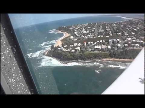 A quick fly down the Caloundra beach in a Texan
 -
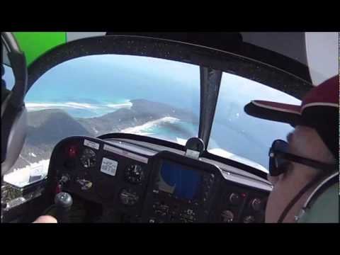 Coastal Flight in a FS Texan along SE Queensland.
 -
I used to fly there in a Cherokee 6 and sometimes a C172. Landings are a non event but take offs required early rotation, then accelerate in ground effect before climbing away due to the sand / grass resistance. Its an easy walk to the beach for a fish or a reasonable walk to the wrecks for a snorkel. Most of the comments above relate to the resort which is south of the wrecks and don't apply around the strip.
-
Me, like many before have had a lot of "in your face" bad moments and nearly all pilots suck it up as training....I suppose it might be the aviation environment and it is all a learning curve even after 500hrs but..... I feel every time a safety issue is raised more restrictions are placed on pilots so that less new members have the privilege of free flight.. Surely it is a better place today than 30yrs ago when I started?? Am I wrong??
-
Hey Pearo, When are you going? I did a few visits into YKBN when it was a resort in a Cherokee 6 several years back. My PPL has lapsed (still RAA) but happy to RHS if interested. PM me if you are going this week. Cheers Matt
-

Plane crashes at Redcliffe in North Brisbane
av8vfr replied to ZeroAlpha's topic in Aircraft Incidents and Accidents
IVW is a C152 aerobat that I trained on in the 80's.. dunno where the $400K figure is from... no-one would put that much into an old 152.. they could have 3x nice new LSA's with full glass for that.. -
I use windyty but also some others are: http://earth.nullschool.net/#current/wind/surface/level/overlay=temp/orthographic=-225.63,-24.46,790 and http://www.goes.noaa.gov/sohemi/sohemiloops/shirgmscol.html which has Oz on the LHS. Handy when tracking Qld cyclones as well..
-
New area - how to know radio reporting points
av8vfr replied to OzScot's topic in Student Pilot & Further Learning
Teewah township is on the VTC at the 65 DME BN, and I imagine replicated on the VNC. There is Ultralight and hang glider symbols also below the township, but my VTC is out of date. Have a look at the VNC legend, shows VFR approach points (diamond) and reporting points FYI. It is better to have your eyes outside the cockpit scanning for traffic, rather than spending minutes looking for a location on a map. In any case, if they are reporting in the circuit and you are en-route (above 1000ft AGL) there shouldn't be any concern. -
^Airshow trick that caught a few out... Select gear up before the take-off and let the "squat switch" or "weight off wheels switch" complete the circuit and start the retract... Then they try to impress with a short roll (T/O while in ground effect?) and as the weight comes off the wheels come up.. usually below flight speed. I think they have abandoned this method of display nowadays..
-
If average is 20 years... this one is 24 years if your data is correct.. Don't forget the Hawaiian Airlines that 'can opened' because of the short distances and high compression rates on the airframe Doesn't that average 1.25 hrs per flight on those figures?
-
I'm on high alert when i approach the cct area, let alone the the landing phase... Downwind checks also are good.. tighten the belts when you do Hatches and Harnesses regardless. You are about to hit the ground (with or without style..lol) Then I do a control check on downwind.. lightly check 3x axis (toes off brakes) especially the yaw. Wakes up your senses when the a/c skids and skates a bit but also affirms your control.
-
Nice BRS save. (Cirrus out of fuel over ocean.)
av8vfr replied to Garfly's topic in AUS/NZ General Discussion
I think having notified the authorities such a long way out indicates he was monitoring fuel and probably did all he could to transfer fuel. If what I read above is true, I doubt it would have been his preference to pull the handle. I did note the door open on descent as I was taught for ditching, because impact may distort the airframe and lock you in.. maybe more so in ally aircraft than glass?? -
AirAsia Flight QZ8501 Missing
av8vfr replied to Rotorwork's topic in Aircraft Incidents and Accidents
So if both want priority, how does the aircraft react? Also, if the captain gains authority, a simple push on the FO button will diminish command? Thanks for your insight Dutch, it's the digital flight system I am interested in... each aircraft manufacturer has its own flavour. -
AirAsia Flight QZ8501 Missing
av8vfr replied to Rotorwork's topic in Aircraft Incidents and Accidents
I thought in an Airbus that the two sticks are not directly connected (fly by wire).. ie one can push full nose down and the other full nose up. Is there a switch to transfer authority? Or is the captains stick in command at all times, with inputs from the FO only if the captain has no input? -
I have flown a P2008 with an 912iS and even though my flights were without incident, others had issues with the systems (warning lights). Having said that, I have flown a later model Sling and it purred. Noticeably, the pre-flight check on the Sling does not check each of the ignition systems(Lane A and Lane B) individually as the Tecnam did (like checking mags). Also, the fuel pump (HP) has to be running all the time due to injectors.
-
RA-Aus flying schools in Brisbane
av8vfr replied to 2tonne's topic in Student Pilot & Further Learning
From a GA back-ground around YCAB, I can advise the following: go to http://caboolturerecreationalaviation.com.au to fly in Jabs / Foxbat, etc. I did my tailwheel in a cub L4 for my tailwheel endo and awesome training, especially if moving to from GA to RAA go to http://www.goflyaviation.com.au for RAA training... all with Rotax engines and mix of A/C and awesome staff.. best way to complete your RAA certificate... most with colour lcd screens nowadays.. go to http://www.aerodynamic.com.au for GA training.. will take you all the way to ATPL and beyond if your wallet is happy. Again great staff and Brian knows his stuff. Fleet is aging though. Cheers, Matt -
US plane in Sydney. Picture. Question.
av8vfr replied to flying dog's topic in AUS/NZ General Discussion
Sorry, I took the OP and the one above as it was definitely a Boeing and not an Airbus.. ie a Boeing with winglets Obviously an Airbus in the attached pics -
US plane in Sydney. Picture. Question.
av8vfr replied to flying dog's topic in AUS/NZ General Discussion
Maybe ECM antenna winglets modified for a Boeing??? Some of those have a lot of self defense systems on board (as you would expect) A pic would tell the story though.. -
I read this as a commercial licence to harvest croc eggs maybe? Nothing wrong with a private pilot flying someone to a location for free. Doesn't appear he needs the fuel money..
-
Everyone has heard the "those that haven't, will" scenario. Yet I bet that there are heaps (including me) that run the landing drill and there is no problem.. How many get the "mixture rich" wrong and the engine won't start.. not a problem cause you are still on the ground but do a second take and they are away..
-
Oh BTW... can someone put this in a Tucano and sell it for $50K so I can buy a squadron.... thanks..
-
Same here personally.. except power is the same but weight is doubling every 5 yrs...(not really lol)
-
From memory, there was a successful one in New Zealand after take-off. Apparently double-engine flame-out after ingesting water off the runway from the nose wheels. They modified the sidewalls of the tyres to deflect water down after this one. I think over +4G involved an overstress inspection. I was in Butterworth when we lost that one.
-
This.. Still need a bottle tho..
-
I found it interesting as well. I was an avtech in the 90s on the pig but didn't realise they did spin testing (in scale!) I think spin recovery from 200" subsonic hard ride TFR was unlikely (lol)..., otherwise from altitude they still have the bang handles imo.....lol Magic aircraft, I miss it...


