ianrat
-
Posts
138 -
Joined
-
Last visited
Content Type
Profiles
Forums
Gallery
Downloads
Blogs
Events
Store
Aircraft
Resources
Tutorials
Articles
Classifieds
Movies
Books
Community Map
Quizzes
Videos Directory
Everything posted by ianrat
-
I have flown in a few aircraft including the Cheetah and my self and two other mates flew the 601 XL on the week end and we have order three kit (one each)from Sport Air on the Gold Coast. It is a very easy plane to fly and we cruised around at 110-115 knots and the winds where around 15 - 20 konts. The plain did not jump around and just flew straight and true. A pleasure to fly. Cannot wait for the kit to arrive. Ianrat
-
This is the site that i have tried to contact. I have sent a number of emails that have not been returned and when i try to call all i get is a answering machine. (and living in Australia they will not call back). I am also going to build the CH 601 and i like the spec of the corvair. Ianart
-
Dose any one know if there any Corvair Motors for sale in Australia. I have email Wayne Williams in the states a couple of times now and have not gotten any replies back. Ian Rat
-
My Airmap2000C some times does the same thing. The way I fix my unit is to take out the SD card and then switch the unit on and let it start up all the way. It will come up to a blank map screen. Switch off the unit and re insert the SD card and re start the unit. This should fix the problem. They tell me it is a map problem on the SD card and not the unit it self. Ianrat.
-
We have one almost ready to fly. It has been scratched built. I hope to be able to send for a kit for the second one. We have a few others in SQ and Northern NSW that have the CH 701. They are a good STOL plane (not to fast). Feel free to contact us with any further questions.
-
I have been looking for a program to up/down from my Lowrance airmap 2000. I have come across one (Freeware) at the following site http://www.gpsbabel.org/. I have been able to up/down load my Way points, Routes and Tracks and then show them in Oziexplorer. I have also created my flight plans using Ultranav and then up laoded them to Oziexplorer, laid them over the VTC or WAC chart, checked them and then up loaded to the Airmap. I hope that this may help you. Ianrat :)
-
I have been looking for a program to up/down from my Lowrance airmap 2000. I have come across one (Freeware) at the following site http://www.gpsbabel.org/. It seems to be able to handle a large no. of GPS units. I have been able to down load my Way points, Routes and Tracks and then show them in Oziexplorer. I hop that this may help you. Ianrat
-
Thank you for the information. I will give them a call and get some more details. Ianrat
-
Has any one imported a kit from the USA. I would like to bring one in but i am having difficulties in finding out any information on the right company to use and what cost would be incurred. If so who did you use to transport the kit. How much did it cost. :;)5: Thank you Ianrat
-
I have also used the Ultranav program. For the cost of the program it works very well. The final map section is a bit so so but i have never had it crash on me. I sent an email and received the latest ERSA update. I like the ability to either select a Airport, Nav Aid or you can just select a town and then insert into your plan. Ian Rat
-
I believe that the Airmap 2000C that is sold in Australia has the same maps as the one that I have purchased in the States. Before I purchased it I went to some length to make sure of it. I also have three other friends that have the same unit, 2 purchased in OZ and one from the States. They all seem to have the same maps. One of the things that you will notice is the absence of Lake Wivenhoe just out side Brisbane. It just isn’t there, but the Atkinson Dam is shown. Lake Wivenhoe was built less than 50 years ago. As for the Avmap. The reasons that I like it is because it has a bigger display and the ability to split the screen is also plus. It has the same Terrain Awareness but it has the Low Airways included. It also has the ability to be used in portrait mode. Not like the Airmap, the all of the accessories have to purchase separately. It can be used on your knee (knee pad sold separately) or you can mount it on a raised knee board (sold separately). I do not believe that it come with any mounting hardware (Yoke mount). The size of the unit is good for reading, but it make the mounting into a panel of a small ultra light difficult. The Airmap 2000C has performed all of the tasks that I have put to it. And at the cheaper price I am happy with the purchase. I hope that this has been of some help
-
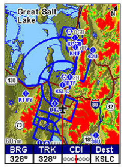
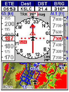
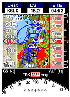
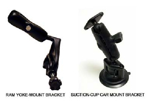
I looked around at most of the units available. I like the Airmap 2000c for a number of reasons. I purchased the International version while on holidays in the USA. It cost me $795.00 US dollars that converted back us Aus $1030.00. The same unit in Australia sells for about $1700.00. It came with the latest Jeppesen Charts and the Terrain awareness for most of the world and has a base map of the world. The maps of Australia are about 50 years old but the details are still good enough to be able to fly to most area with ease. You can put your own way points into the unit, so if the map is incomplete you can still use the unit to get to where you want to go. The screen is big enough but not to big to fit most Ultra light panels. You can buy a docking station for the unit that allows for easy removal. The unit that I would have liked is the Avmap, but with a price tag of around $2200.00 I could not justify the increased outlay. I am still finding different ways to use the unit with it many types of screens, from full maps to split screen to HSI and the Terrain with Airspace displays, very good when you are flying near controlled airspace. It will pop up a screen to alert you that you are about to enter the controlled airspace. It also has a graphical section with the relevant height restrictions for the area a head. When flying with most of the displays the terrain awareness will turn the areas in your flight path red if your height is lower than the object or area that you are flying towards. With the push of two buttons you bring up the entire registered air strip in the Ersa that are close to your locations (very good in the case of an emergency). And then set up a navigation track to that air strip. The Airmap is supplied with a list of extras, it comes with an external antenna, yoke mount, 12 volt power cord, suction cup mount, plastic cover and the Map Create program (Very detailed maps of the USA. good if you live in the USA). The unit has 4 AA batteries but they will only last about 2 hours, good for setting up the unit in the lounge chair before take off, so they recommend that the external power cord be used. The colour screen is easily seen in day light. You can also purchase Marine navigation charts and just insert the card into the unit and then use it in the boat. It is water resistant (to a depth of 1 mtr for thirty minutes I think). So far I am impressed with unit. It has not let me down yet. I have seen other units like the Enigma that has a map and flight and engine monitoring all in the one unit. I personally like to have a separate unit so as not to be changing screens all the time to monitor maps and engine. On the Lowrance web site you can down load a simulator and tyr some of the fearture on your computer before you make up your mind. Hope that this has helped you. Here are some of the different displays [ATTACH]2207[/ATTACH] [ATTACH]2208[/ATTACH] [ATTACH]2209[/ATTACH] [ATTACH]2210[/ATTACH]

-
I have purchased a Lowrance Airmap 2000c International Version. The SD card that has been supplied is only small. I have purchased a new 1 Gig card and would like to transfer the Maps to the new card. I am aware that the Jeppesen Charts and the Terrain awareness file will have to be purchased again to fit on to the new card. The maps that come with unit are for the rest of the world with exception of the USA. On the supplied card there is only one map file. When i use the Map Create program to put the new maps on, my computer only hangs up. Has any one else been able to move the maps over.
-
We have just about finished a 701. It has been scratch build from plans. Having to make all the parts our selves it has taken a while to complete. I have flown in both the 701 and the Savannah (both with and without the slats) There short take off and landing impress me. At Natfly 2007 I had a fly in a savannah without the slats; we landed on runway 11 on the threshold at the end of the runway and still had plenty of room to pull-up and turn onto the taxiway. The new 701 kit has many of the sheets now pre drilled. As soon as I can sell my boat I will be ordering a 701 kit in from the States. I know off about 4 other 701 in the SE QLD area. All happy with there planes. Please contact me if you would like any further details. Ian