Garfly
-
Posts
3,056 -
Joined
-
Last visited
-
Days Won
67
Content Type
Profiles
Forums
Gallery
Downloads
Blogs
Events
Store
Aircraft
Resources
Tutorials
Articles
Classifieds
Movies
Books
Community Map
Quizzes
Videos Directory
Everything posted by Garfly
-
Yes, the link above is from that series, located in the sidebar menu: "Resources >> Tutorials". Section 6.3 seemed a likely candidate for "anything else"; key information which may not get its due in the PPL subjects listed in the original post.
-
That'd be John Brandon (see post above).
-
Yes.
-
 I'm not sure about that, Mark, but thanks for the tip. I'll have it checked out.
 -
Yeah, Glen's (RFguy's) design definitely looks the go (when it arrives). I've had the MGL V16 with Vega head for a while now. I like its features and its overall quality. I'm having some problem with intermittent noise in the system but I doubt it's the radio itself that's to blame. (It's at its worst taxiing as if there was a dry joint somewhere in the audio-out chain. I have checked the obvious ones like the headphone output sockets without luck, so far.)
-
How have you been finding your MGL V16 Mark? What control head do you use with it?
-
I would definitely recommend taking up Franco's great offer but if your son is not able to travel down there, then you might just want to get him a gift-voucher from the the North Queensland Aero Club based at Mareeba airport. https://www.nqac.com.au/gift-vouchers
-
HARS = Historical Aircraft Restoration Society https://hars.org.au/

-
Two helicopters collide on the Gold Coast 02/01/23
Garfly replied to red750's topic in Aircraft Incidents and Accidents
-
Bienvenue Phillippe, As you probably know it's a very long way from Wollongong to Mareeba (like Paris to Morocco ;- ). But I guess you're thinking of a flight around the Mareeba/Cairns area, rather than around Wollongong, is that right? Maybe some people on this forum from up that way could help with suggestions. Anyway, if you check out some of the great movies on this thread you will see that Far North Queensland has some spectacular scenery to fly over:
-
Jab down in Wentworth 2 Jan 23.
Garfly replied to BirdDog's topic in Aircraft Incidents and Accidents
Anxious that my steed and/or myself might appear in a thread like this some day, I'd like to say a word for this plane and pilot (pending due process): blameless. -
Who's wrong? ERSA or Google Maps?
Garfly replied to old man emu's topic in Student Pilot & Further Learning
That old path is sounding less and less virtuous by the minute. -
Who's wrong? ERSA or Google Maps?
Garfly replied to old man emu's topic in Student Pilot & Further Learning
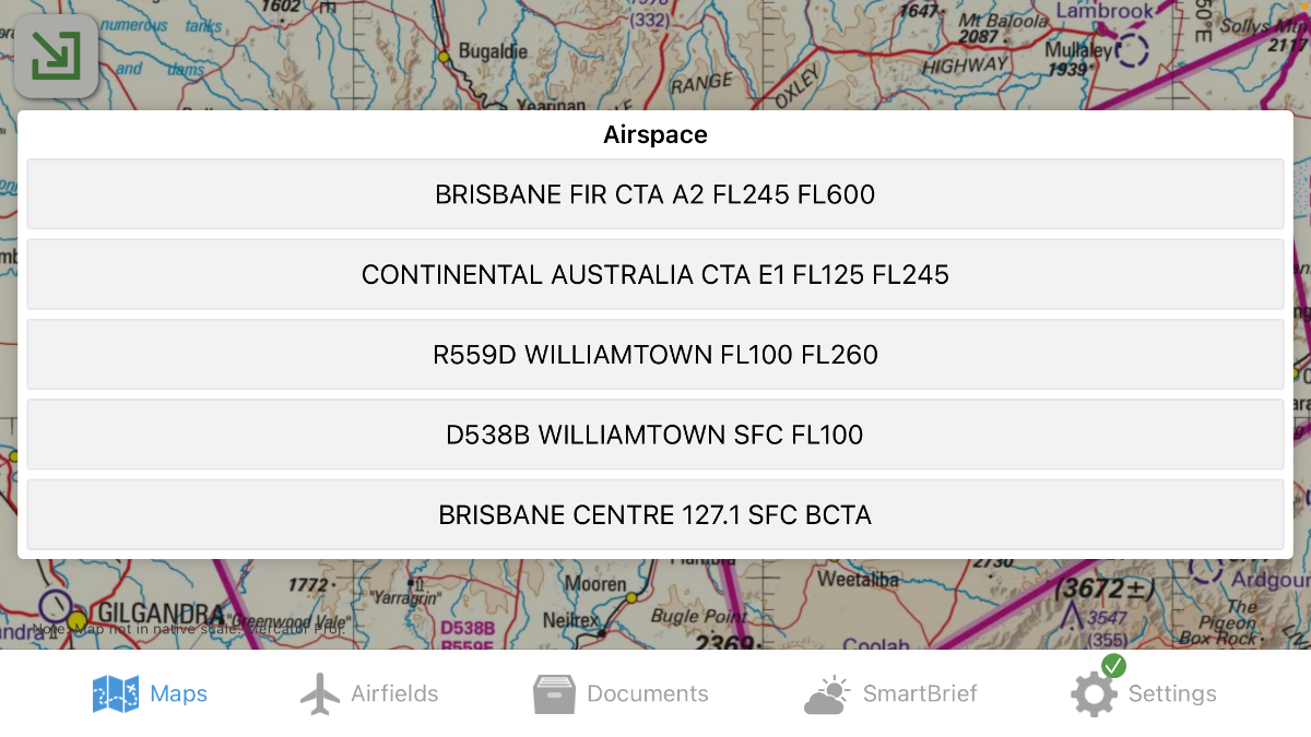
Actually the new WAC itself doesn't offer much guidance on the Romeo areas contained in those magenta boxes. However, a single long press on your EFB screen will reveal that R559D and R559E are active only between FL100 and FL260. So no sweat. CLICK FOR FULL REZ:
-
Who's wrong? ERSA or Google Maps?
Garfly replied to old man emu's topic in Student Pilot & Further Learning
But since we're talking Toora we can bank on variation (in our lifetime, at least) to remain at 11 - legs eleven - degrees, East. ;- ) -
Who's wrong? ERSA or Google Maps?
Garfly replied to old man emu's topic in Student Pilot & Further Learning
I'm not sure how Google Maps handles that but the app is not really designed for that sort of thing, is it? Even if you never want to take one of those new fangled EFB gizmos aloft, I'd strongly recommend using one of them for the job at hand. It'd make it so much simpler and better in so many ways. By sticking to "the narrow path of virtue" (to borrow Nev's phrase) even for the planning phase, I reckon it's going to be harder and less accurate. Unless you reckon virtue is its own reward. ; - ) -
Who's wrong? ERSA or Google Maps?
Garfly replied to old man emu's topic in Student Pilot & Further Learning
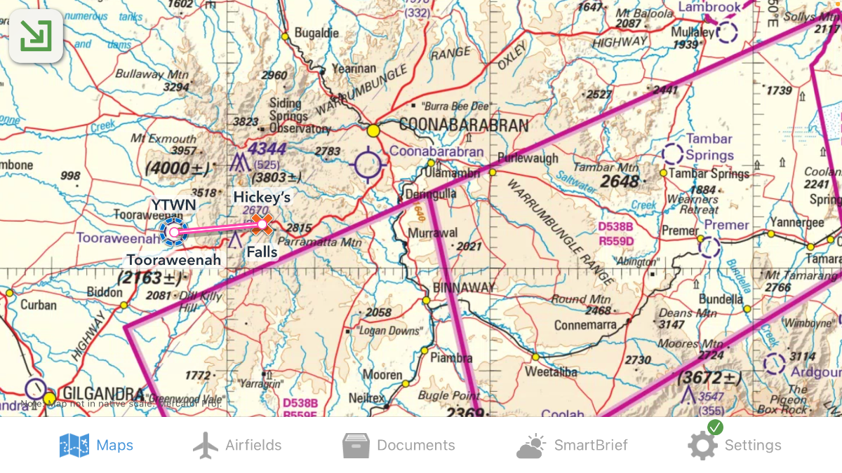
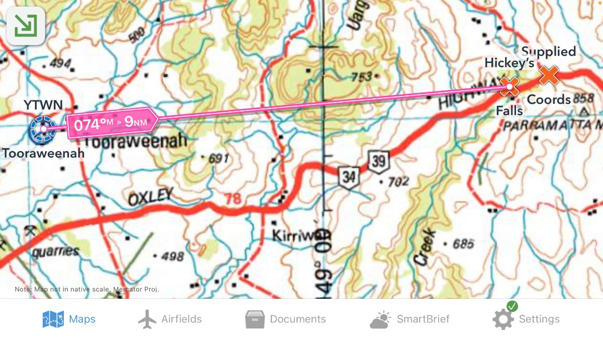
Okay, that looks good. I can see that the precise location of the Falls themselves is not important in context. The road intersection is the waypoint. I suppose you could also play with what3words fixes, which, I reckon, would put the actual falls at magician.opening.aboard and the nearby intersection at uninspired.outsize.strategist and YTWN at assertions.springtime.investigated ;- ) -
Who's wrong? ERSA or Google Maps?
Garfly replied to old man emu's topic in Student Pilot & Further Learning
I prefer to use the DMS coords because that's how my OzRwys - and Google Earth - are (usually) set up. But anyway, for me, both apps (notwithstanding the different formats) placed the coordinates quite close together but at a distance of about 1.5 km to the east along the highway, from Hickeys Falls. I used GE first, to locate the place by name (it's not on any of the charts I have in OzRwys) and then matched up features to confirm and cross check. I placed the falls themselves (just north of the associated carpark) at 312543, 1490401 Or, in our sort of lingo, approx 9nm on the 074 radial FROM YTWN. Are those the kind of results you were expecting? CLICK FOR FULL REZ.
-
Who's wrong? ERSA or Google Maps?
Garfly replied to old man emu's topic in Student Pilot & Further Learning
Oh, for sure, I take those coordinates [S31deg26mins24secs / E148deg54mins02secs and 312630S / 1485400E ] as the same thing for our intents and purposes (global bulges notwithstanding ;- ). I only meant to draw attention to the format ERSA uses and how ambiguous it could be for pilots, on quick viewing (as opposed, to geoscientists et al, who use all the various formats regularly). I haven't kept my eye on just how ERSA denotes lat/long (we rarely need to match coordinates to maps by hand, these days) so, I could easily have made the same mistake you did. So I reckon it should be disambiguated. -
Who's wrong? ERSA or Google Maps?
Garfly replied to old man emu's topic in Student Pilot & Further Learning
I think the problem might be that the latter figures quoted could be minutes and seconds. OzRwys has it at S31deg26mins24secs ; E148deg54mins02secs EDIT: Yeah, it's a bit ambiguous the way ERSA writes those figures, that is: "312630S 1485400E" in a document where ambiguity can be a big problem. Mt Erebus comes to mind. -
True! That's Recreational Boating.
-
Yeah ... ya gotta miss the virile societies of our forefathers, where women (and other out-groups) knew their place, and nary a hoon would be found (alive). Cue Tucker larf:
-
Just came across this other Juan Browne cautionary tale about a rejected take-off :
-
Severe Turbulence: Unravelling the Botany Bay Airliner Crash of 1961 Peter Hobbins Hobbins - Severe Turbulence (2022).pdf https://trove.nla.gov.au/newspaper/article/105854382/11503817
-
More like "We ignored the wisdom of the RecFlying collective!"