flying dog
-
Posts
1,758 -
Joined
-
Last visited
-
Days Won
2
Content Type
Profiles
Forums
Gallery
Downloads
Blogs
Events
Store
Aircraft
Resources
Tutorials
Articles
Classifieds
Movies
Books
Community Map
Quizzes
Videos Directory
Everything posted by flying dog
-

Enough to scare the pants off you
flying dog replied to red750's topic in Aircraft Incidents and Accidents
As I mentioned at the start I can't see the original clip. (Such is life) Where/how do I unsubscribe from this topic? Its a bit pointless getting reply notifications Found it! Sorry. -
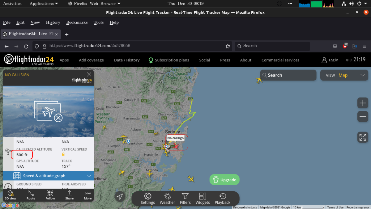
I saw it and checked "Flight radar" but it was not shown. 😞 4 prop high wing Military? C130? Departing YSSY West bound.
-
Enough to scare the pants off you
flying dog replied to red750's topic in Aircraft Incidents and Accidents
😞 facebook. I've blocked that from my network. -
I would hope you also would have wire cutters at the top of the vertical stab' also!
-
Yes, that is a shocking case of poor CRM. Luckily nothing bad happened.
-
Yes, if I read every word of every post I will see what I am about to ask. Sorry I am really having a bad time parsing things. Sticking to android, what are the apps for flight planning?
-
That reminds me of another scenario where I am kind of glad we got through it. "Weekend fly to Narromine" from up near Caloundra." Got down to .... Walcha. See the relo's. Got to their house and it started PISSING DOWN! Had to stay the night. Next day the plane was saturated - inside - and we pressed on to Narromine. Maps/charts pretty well a write off. (As was most paper work.) The radio was kaput and it was a real mess. Won't be flying with that person again either.
-
Sometimes. I already know the car's endurance and so if it is to a known place and I know how far it is, the fuel calculations are sort of automatic. But I shall mention something on that shortly. I don't do much country driving so I don't worry too much on the weather. But once I was "helping" someone drive their "petrol guzzler" from Sydney to Melbourne towing a heavy trailer. I got to do the second part after.... Gundagai. We stopped there and had "lunch", filled up and that was that. We're driving along and I'm doing on, but there is no "flight plan" in the GPS - other than "this is where you are". I glanced at the petrol gauge and noticed fuel was getting scarce. LUCKILY! We pulled over, unhitched the trailer - and I stayed with it - and the car was driven back a few K's to fill up. I was annoyed no end that I was driving a car with no knowledge of how far it could go and wasn't told where/when to expect the next petrol station. I won't be making that mistake again. Not travelling with that person any more. But it was an interesting experience to say the least. WATCH THE FUEL!
-
Wow, this is overwhelming.... Seems I may not be making any XC flights for a while. (Though I haven't flown for about 3 years.) 😞
-
> My own Excel Navlog That is a blank one which you then fill out with the new/up to date information - yes?
-
Yeah, fair enough. I just wasn't sure what you meant. I have a GPS that I use and with which I am happy. But you mentioning the importance of papers, I was once flying and 20 minutes into the flight, the battery in the GPS gave out. No big... I used the paper plan I had and kept flying.
-
(ARGH! trying to cut your text to paste here is like herding cats!) Yeah, you are right... I could just scribble down on the paper what I am shown. > But then you have every possible chart always up to date (could even be cheaper in the long run). Which way sorry? Having the "Ipad" or maps? (given there are ongoing costs with the tablet of data costs)
-
Wow, I opened a can of worm here. Yeah, ok replying as I remember them: Yes, silly as in the weather forecast will/could change. I am not an apple person. I'm android. And yes I know there are apps for that too. But that (in the bigger picture) is not congruent with what I was told. You need a PAPER flight plan. None of those give you that. I've just bought myself a newer phone (from an old S5) and it does have more "grunt" and all that. But the screen size is not the required 10 inches - if I remember correctly. I don't mind doing as suggested and doing it both ways to start with, but that doesn't answer the question about the legalities of not having a paper plan at the end of the day.
-
I am a dinosaur and make my flight plans with paper. I have an EXCEL sheet to do distances, tracks, etc. Then I enter the wind and it calculates the important stuff. But that means I need my COMPUTER and PRINTER handy all the time. So when I get back to flying and doing XC flights: how do I make a plan? It is a 1.5 hour drive to the airport, so making a flight plan at home is silly. How are they done nowadays?
-
(Although I am also still debating should I go with FS2022 or Xplane) From my past days with FS9 I have a few instruments (Panels) and I am slowly thinking of getting my new machine working with one (or maybe both) FS. I have: MCP Radio/COM panel (two displays and knobs to adjust the frequency) Landing gear 8 x buttons 8 x switches 4 x knobs - Xponder mostly. A radio control panel - as in volume, squelch and something. (It is 20 years or so since I've used it) 6 lever throttle. (speedbrake, 4 x throttle and flaps.) (All the above is from Go-Flight) I also have (somewhere) a couple of Saitek's square things that can be different things. HSI, Radio, and other stuff. Alas I bought them impulsively and they needed FS10 to work. All I had was FS9. I guess one big question is would they still be supported? I'm guessing most would as I've seen Go-Flight are still in business. But they were (then) only for FS-n stuff. Not XPlane. Does Xplane support them? What would be a good layout for them?
-
I read the post as "Autonomous cars drive with the idea that every car drives safely." > but fully automated ones are expected to never do so. That is a good idea/theory, and would be valid most of the time. But if one of these cars went crazy and wasn't driving safely, then YOUR self driving car would have to deal with a car which wasn't obeying the rule just stated. (All cars drive safely.) And so it would be confronted with an unknown scenario.
-
I heard something similar and nearly included it, but...... I don't want to push the friendship. 😉
- 1 reply
-
- 1
-

-
Alas I fear that is a big problem / flaw with that idea. It is wrong. If another self driving car is near by and *something goes wrong*..... All bets are off. (BTW, the signature of that post was very good.)
-
Someone just sent me this link....
-
Ok, thanks. I guess that does make sense in most ways. I guess I am just getting caught up on the small things.
-
Nowadays you can get weather reports for your suburb, which is kind of nice but I saw something today that has me confused. The forecasts include temperature, clouds, pressure, precipitation and so on. How can you have RAIN when the CLOUDS are CLEAR? If there are any clouds I can get that you can get rain falling from them and if "unlucky" (or lucky) it falls in the sensor, and so you are told of rain in the area. But when it says CLOUDS: CLEAR and shows RAIN I don't understand. Even if they weren't "real time" and from .... 20 minutes ago..... How can you have RAIN if the sky is CLEAR? I don't know if that is rhetorical or not.
-
To digress - well, I posted the video above. Believe it or not. But I don't think they were sitting there telling that story and it is/was a lie.
-
Ok, it (the helicopter) wasn't TCN-9. (My bad). Oh, and that "UFO": It's ground speed as 158, so it wasn't slow.
-
Heard the TCN-9 chopper today (Thursday) 08:20 and also saw this thing.