dsam
-
Posts
493 -
Joined
-
Last visited
-
Days Won
4
Content Type
Profiles
Forums
Gallery
Downloads
Blogs
Events
Store
Aircraft
Resources
Tutorials
Articles
Classifieds
Movies
Books
Community Map
Quizzes
Videos Directory
Everything posted by dsam
-
 Yes, it is nuts! To be clear, my aircraft fully complies with CTA access, and can enter C & D airspace with a PPL pilot in the left seat (and I have already done so legally). I have an RA-Aus Pilot “Certificate”, therefore I shall not enter as pilot-in-command! RA-Aus authorities have been negotiating this unfair anomaly with CASA for the last two years (or more) without result. Of course I’m happy to comply with any proposed endorsement exams, CFI check flights in my aircraft, etc. etc. but nothing has happened yet!! Very frustrating! I’d love to fly up the coast to Far North Queensland, but cannot do so without CTA transit rights. Instead, I’m forced inland over mountainous & often cloudy terrain ducking under CTA steps, or perhaps even further inland into remote outback territory. C’mon bureaucrats! Get going on this endorsement:angry:
 -
Another form of "Tiger Country" involves Bass Straight crossings (AIP SP1). In my case, I did the recommended track over Flinders Island (via Cliffy Island, Hogan Island, Deal Island then via Cape Portland or Waterhouse Island). Many of these islands are very rocky looking from above, and seem not viable for a good landing should the Rotax 912 fail. Of course I did the recommended SKED reports at 15 minute intervals, at flew at high altitude (8500 & 9500) for best glide range - so only travelling in ideal weather helps here. Also mandatory was my life jacket & floating PLB, personal strobe, and for extra help, my SPOT locator, OzRunways tracking, and ADSB-out. With all of this, I still considered it a calculated risk and flew solo, not feeling I could put someone else at the same risk in my Eurofox. I'm happy to report that my journey went just as I (carefully) planned, and was without incident. Being RA-Aus, I have no access to Class D at Launceston, so I had to track along the north coast to Devonport to re-fuel, making my journey much longer for no good reason. The regulations as they currently stand are very discriminatory towards RA-Aus pilots, forcing us low under CTA steps in rough tiger country, or preventing me having Class D access at Launceston when that would be shorter & safer for Bass Straight crossings. I wish CASA would do as their name implies, and put RA-Aus pilot's safety ahead of their bureaucratic intransigence on CTA access/transit.
-
- Disorientation in cloud - Untrained low level circling in wind, caught-out by illusions of drift and uncoordinated flight controls & insufficient speed.
-
Just a small additional point to add... many aircraft are designed with a dihedral wing. The lift vector of each wing (L & R) is therefore slightly different, and becomes an additional consideration in a full-detail vector diagram of a banked turning aircraft. Skidding or slipping turns with a dihedral wing bring even more asymmetric forces into play. A mathematician’s picnic! Insane! For my sanity when low or in circuit, I prefer to only think about keeping the damn ball centred, and never forgetting the three S’s (speed, speed, and speed). Hit your correct speeds in coordinated flight, and avoid being a statistic - no vector diagrams required:unhappy composer:
-
A firm stick forward with EFATO is always going to be my first instinct. That became drilled into me as a 15 year old learning to fly draggy 2-seat training gliders on winch launch, where the winch cable could be expected to break at any time. Typically, that happened just as my stick came fully back, establishing a climb to apex! The loud Bang sure gets your attention too:yikes:
-
Thank you, and best wishes for the festive season!
-
Dynon SkyView - now with OzRunways!
dsam replied to KRviator's topic in Instruments, Radios and Electronics
Well that’s a good response from OzRunways! Well done to them for looking after legacy iPads and software:prop: -
OzRunways as Nav Student?
dsam replied to HonkyNerdPilot's topic in Student Pilot & Further Learning
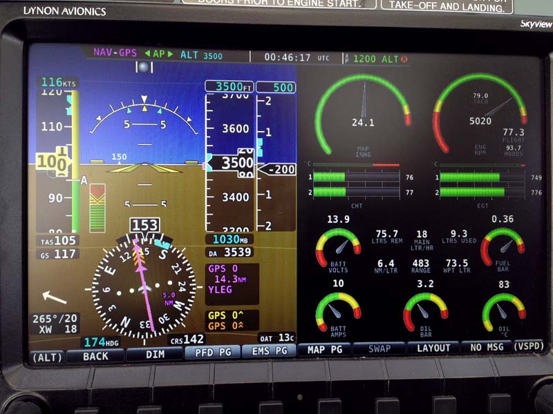
There is a crossover benefit derived from knowing and fluently using iPad EFB's. Both OzRunways and AvPlan provide files for Australian Airservices moving-map displays on "glass cockpit" devices such as the Dynon Skyview (as depicted below). A quick glance across the Dynon & iPad shows me a wealth of situational-awareness information. I can quickly see navigational agreement across multiple devices & GPS sources (and easily confirm a fix with the ground features below). My iPad's WiFi connection to the Dynon (& its autopilot) allows me to upload the initial flightplan, or if needed, update the flightplan whilst airborne. For me, this becomes a closed-loop system, whereby my pre-flight planning tool, can remain closely integrated with my airborne software & hardware, all of which contributes to safer operations in the modern EFB / glass cockpit era.
-
Dynon SkyView - now with OzRunways!
dsam replied to KRviator's topic in Instruments, Radios and Electronics
That re-boot might help too. (esp. hold Home and Power buttons down for 30 seconds) But more specifically, make sure OzRunways isn’t still active in memory when you link the iPad to the Dynon. I’m assuming you know how to dismiss active apps in an iPad...? (ie. double click home button and swipe-up all apps you wish to dismiss - in this case, all but the Settings/WiFi app you use to connect to Dynon). Sorry if I’m stating the obvious to you:blush: -
Dynon SkyView - now with OzRunways!
dsam replied to KRviator's topic in Instruments, Radios and Electronics
oh...crap luck.... Yes, I have an iPad Air 2 with the latest iOS. What I can say, is that I experienced the same issue as you when I left the OzRunways app open. To be clear, I had to dismiss from memory OzRunways and only launch OzRunways after knowing my iPad WiFi was connected to the Dynon. Only on a “fresh” launch of the OzRunways app would the menu show Dynon as an option in that menu. That’s about the only tip I have... -
Dynon SkyView - now with OzRunways!
dsam replied to KRviator's topic in Instruments, Radios and Electronics
Hi KRviator. It works for me. I’m using the Dynon WiFi dongle (connected at the back of the display). Firstly, I make sure My iPad is connected to the Dynon WiFi signal. Only then do I launch OzRunways with my plan active on map-view. Then I tap the icon at the top of the screen that “shares”, and you should then see an option for OzRunways. Tap that, and the Dynon receives your flightplan almost instantly. I hope that helps... -
2 wingsuit flyers BASE jump into a plane in mid-air.
dsam replied to red750's topic in Aviation Videos
The next time somebody tells me to “go take a flying jump” I’ll know just what to do! Very skilled... and very crazy:loopy: -
Lessons to learn from the ditching of an LSA over water
dsam replied to NinjaNate's topic in AUS/NZ General Discussion
I suppose better planning and preparation are the main takeaway lessons here. Many other things come to mind, but I’ll be charitable for now... It’s interesting to note that a flip-over upon ditching isn’t always a likelihood. I’m also wondering how their “ForeFlight” iPad software compares to our OzRunways & AvPlan? Both of the latter offer excellent situational awareness, (frequencies, options for alternates, notams, traffic, weather etc. etc.). It sounds like ForeFlight isn’t very comprehensive, or he wasn’t fluent in its use. -
[26 Nov 2017] Lilydale Air Show 2017 (Yering Vic)
dsam replied to red750's topic in Trips/Events/Seats
Yes, that’s why I crossed my fingers... Knowing that Melbourne’s weather is notoriously changeable, it could be all different by the time Sunday rolls around:bad_mood: -
OzRunways as Nav Student?
dsam replied to HonkyNerdPilot's topic in Student Pilot & Further Learning
Considering the original post was for VFR operations, let me state the obvious regarding weather-info on EFB’s: keep your eyes mainly out of the cockpit! It isn’t really relevant to me whether the radar trace is 6 minutes or 16 minutes old. If I see a nasty storm-cell directly ahead, sensible airmanship dictates that I’m not going to aim for it regardless of what my iPad tells me! Instead, I’ll divert and use whatever electronic tools I have at hand to modify my flightplanned route to keep safe and clear. That’s not saying the iPad wx info is useless - quite the contrary. I’m a big advocate. Preflight and airborne, it all benefits safe airmanship and situational awareness. As always, common sense should prevail. -
[26 Nov 2017] Lilydale Air Show 2017 (Yering Vic)
dsam replied to red750's topic in Trips/Events/Seats
I plan to attend this. Fingers crossed for the weather to stay kind... -
OzRunways as Nav Student?
dsam replied to HonkyNerdPilot's topic in Student Pilot & Further Learning
I’ve resisted posting here because there is considerable heat in this discussion, but thought I’d tentatively contribute (considering the thread drift since the original post). Here are my observations following extensive RA-Aus (day VFR, OCTA) outback trips: I have both OzRunways and AvPlan on my iPads. I prefer the user interface of OzRunways over AvPlan, but both are terrific contributors to airborne situational awareness, and preflight planning. I am a strong advocate of modern devices, and redundant independent systems onboard, (including printed maps from my EFB following my planning). My Dynon Skyview has 2 non-tso’d independently powered GPS sources driving the autopilot & moving (Airservices) map. I fly with 2 iPads and 1 phone (all with both EFB’s). My primary iPad remains as a kneedock and has never overheated airborne (though it remains a possibility - along with an overheated knee!). In some 260 hours of Australian flying (some very remote) I have never needed to revert to my paper maps, as all devices closely agreed with one another (Dynon + mobile devices) at all times, (though I never assume that will always be the case, thus the never-needed print-out maps). As for navigational basic training & instruction, yes, Dead Reckoning, clock and compass should be an initial part of training (just as long division with paper and pencil is taught to school kids before a calculator is used). But most certainly, the use of EFB’s must be a major and necessary part of any flying school’s curriculum, in my opinion (both ground and airborne). Fluent use of modern devices (both mobile and panel-mounted) can only enhance situational awareness, lessen cockpit workload, and provide redundancy & peace of mind. Add to this the supplementary traffic awareness (OzRunways + AvPlan + ADSPi-in) and aviation safety can only be enhanced by such modern-device fluency. Yes, the old ways have their rudimentary, fail-safe value (as I studied them in the 1970’s), but wisely used, the present technology is so much more capable! -
Changes to Melbourne Airspace - Airservices Australia
dsam replied to Jay_1984's topic in AUS/NZ General Discussion
Another earlier (2010) paper-based guide to the Melbourne basin can be found here: https://www.casa.gov.au/sites/g/files/net351/f/_assets/main/pilots/download/melbourne.pdf I keep this .pdf on my iPad in iBooks as an historic reference. Many aspects of that older guide are part of CASA’s online “OnTrack” guide, but you’d need an internet signal if consulting it whilst airborne... Best to do your homework at home! OnTrack | Civil Aviation Safety Authority -
Changes to Melbourne Airspace - Airservices Australia
dsam replied to Jay_1984's topic in AUS/NZ General Discussion
Agreed. The Moorabbin Aerobatic area, and Melbourne Inland route VFR track is marked on the VTC. Whether one plans with paper maps, or EFB (AvPlan or OzRunways) one needs to view all maps thoroughly and take note of details relevant to your flight plan. That necessitates many lines on many paper maps, or lots of zooming in & out on the EFB across the Melbourne area. Airservices could help by including consistent notes across all scales of maps in this area. Perhaps the other capital cities experience similar inconsistencies across their differently scaled maps? -
Changes to Melbourne Airspace - Airservices Australia
dsam replied to Jay_1984's topic in AUS/NZ General Discussion
FYI, I have both AvPlan and OzRunways. Whilst the OzRunways “Hybrid VFR” map seems to require a bit more zoom/expansion for that inset-note to appear, pre-selecting the “Moorabbin Inset” map whilst flying in that vicinity provides all the zoom-out & pan flexibility you are likely to want in that area. That way the note remains always visible with that inset map. -
It seems that OzRunways are soon going to release their own airfield guide: The OzRunways Airfield Guide will replace the AOPA AFD Subscription. All existing AOPA and Premium subscriptions will convert over to the new OzRunways Guide in late November. You won't need to do anything; it will just start working automatically! The OzRunways Airfield Guide is a completely new, ground-up product developed by our data team in accordance with ICAO data processing standards. The OzRunways Airfield Guide will be constantly maintained and always showing the latest data available. You will see more airfields added over time.
-
I should point out that I don't regularly transport my Eurofox via the trailer. Australian outback roads can be extremely punishing to such cargo. For me, it serves as a "hangar" stationed at YLIL. However, should I need to retrieve or relocate my aircraft for repairs from some unfortunate event or breakdown whilst on an excursion, I have a good option to use this trailer to facilitate this. Luckily, throughout all of my outback excursions, I have had no such incidents, and flew home safely. It's not really my preferred mode of aviation, but I would have thought an ideal "aircraft" for ground/airborne outback "tourism" would be a powered parachute setup from the back of a 4WD ute. I have no personal experience with this, but others on this forum may well have much to contribute in this regard.... over to you guys...!
-
FYI, here is an earlier link on this topic: Recreational aircraft with folding wings
-
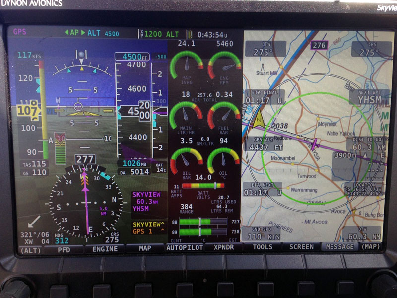
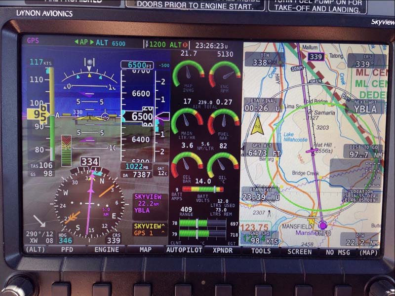
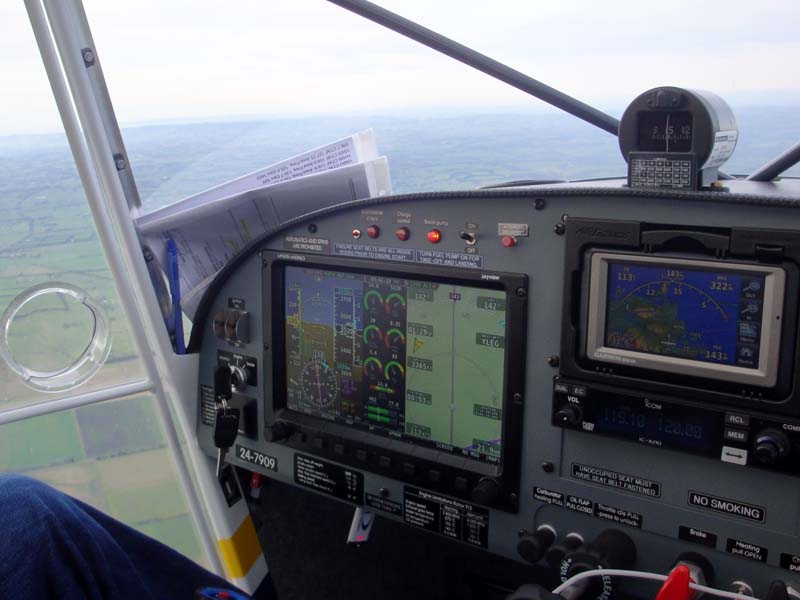
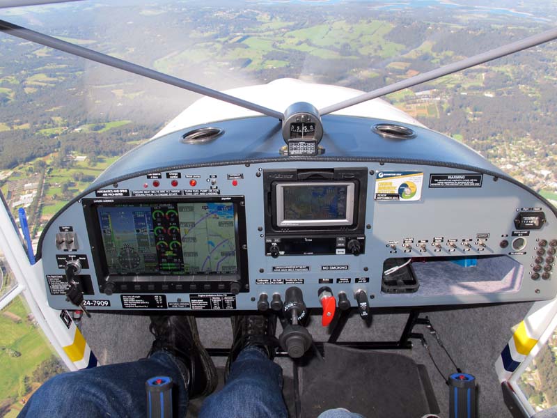
If it helps, here are some views of my instrument panel, and some different Dynon Skyview display layouts that are easy to call up & toggle off. Typically I use the 3-view split with the Airservices WAC at right in a moving map mode, EMS in centre, PFD at left. An ERC Low map and geo-locating aerodrome chart views are also available in that map section. Audible alerts will sound in the headset regardless of the view I have selected. That way I can primarily keep my eyes scanning outside of the cockpit, knowing I will hear an alert if something is amiss that needs attention. I certainly don't experience any display lag that others claim to experience... if anything, I would say the Dynon is immediate for all sensors - perhaps more than conventional instruments.
-
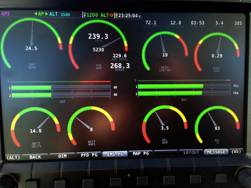
I'm a 60+ guy and am a huge fan of my 10 inch Dynon Skyview in "tape" display mode (I've never bothered with the virtual six-pack display mode). I have no trouble seeing the displayed info, even in bright sunlight. I should add that I often use bifocal sunglasses for flying - no correction straight ahead, + 1 at reading level. The Dynon's vast quantity of info available at a glance, is a huge contribution to my situational awareness at all times. The Dynon operates the autopilot, and I even get vocal warnings in my headset if engine or flight parameters go out of norm. Steam gauges won't give you that. I've never had any issues or failures with the Dynon Skyview in 6 years. It even displays Aussie Airservices maps. I have no "steam gauges" at all (other than the factory fitted magnetic compass), and I wouldn't bother with them. Note that my panel also has a backup gps, and I also carry 2 iPads with OzRunways EFB.