KRviator
-
Posts
1,164 -
Joined
-
Last visited
-
Days Won
17
Content Type
Profiles
Forums
Gallery
Downloads
Blogs
Events
Store
Aircraft
Resources
Tutorials
Articles
Classifieds
Movies
Books
Community Map
Quizzes
Videos Directory
Everything posted by KRviator
-
You know - that's not as stupid an idea as it sounds...Each 44 is 400lbs of buoyancy. Keep 4 or 6 of 'em stacked in the corner of the hangar and 2/3 of those strapped together per wing, a yoga mat or bit of sponge rubber between the drum and the skin and you could well limit damage to just the wheel bearings. That's a cheap, and bloody good idea, @F10
-
Good memory! I even replied there and had forgotten about it! 😛
-
Pretty sure it's legal so long as they are 'approved' ie, have the relevant UN markings on them. From the new CASR: 92.B deals with Conditions of carriage of DG, DG manuals, etc 92.C deals with DG training, 92.175 Goods carried by private operators Subparts 92.B and 92.C do not apply to the carriage of dangerous goods by an aircraft operated by an operator engaged in private (non‑commercial) operations if: (a) the aircraft is operating in Australian territory and: (i) is unpressurised; and (ii) has an approved passenger seat configuration of less than 10 seats; and (b) the goods: (i) are in a proper condition for carriage by air; and (ii) are identified by class in accordance with the Technical Instructions; and (iii) are permitted by the Technical Instructions to be carried on a passenger or cargo aircraft; and (iv) are stowed and secured on the aircraft to prevent movement and damage, and segregated in accordance with the requirements of the Technical Instructions if they are likely to react dangerously with one another; and (c) the pilot‑in‑command of the aircraft ensures that every person on board the aircraft knows, before boarding the aircraft, that the dangerous goods are on board.
-
South Grafton I think is, they're only 1000m from the river, but I had a look at the NSW Gov't SIXMaps page just now and it looks to be protected by a levee bank along the river - but if water gets through or around that, all bets are off I'd imagine! The latest BOM plot for the Clarance River at Grafton shows it to have just peaked at around 7.8m - which is 3.4m above the major flood level. It's now trending downwards slowly, but that may well rise further if they get more rain in the catchment.
-
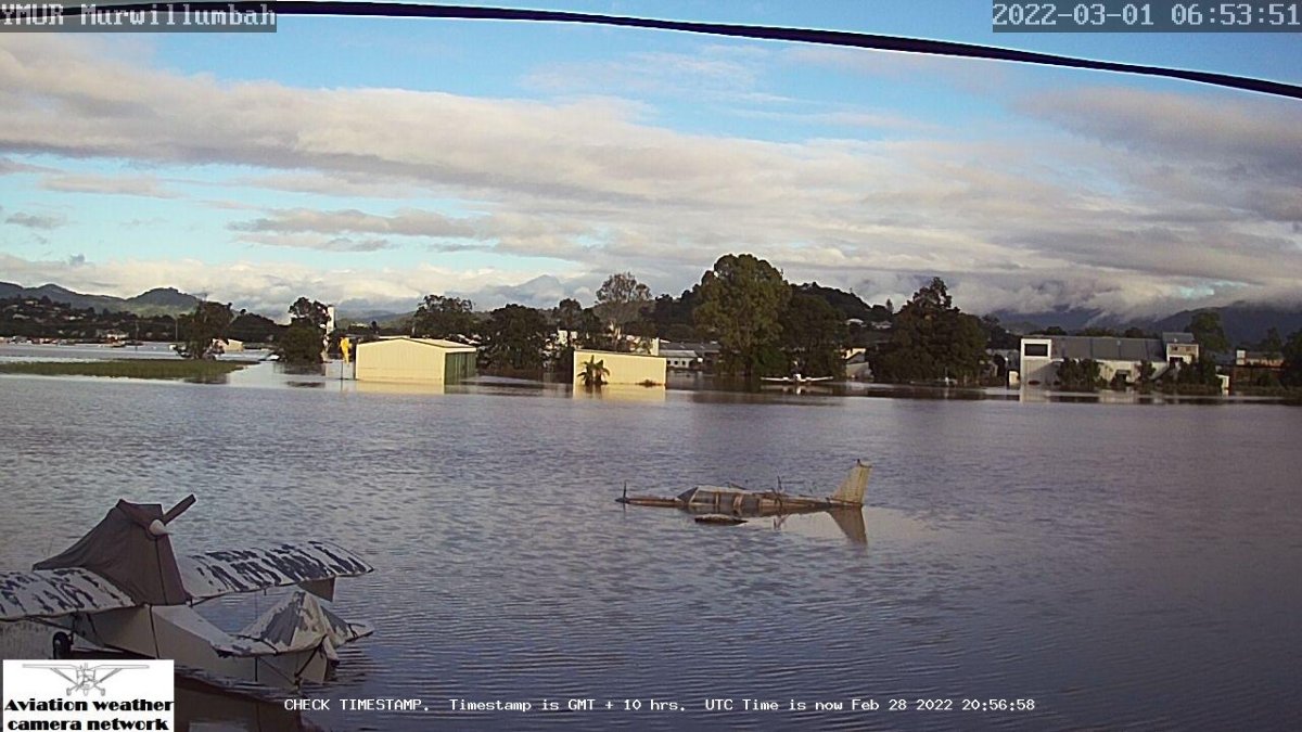
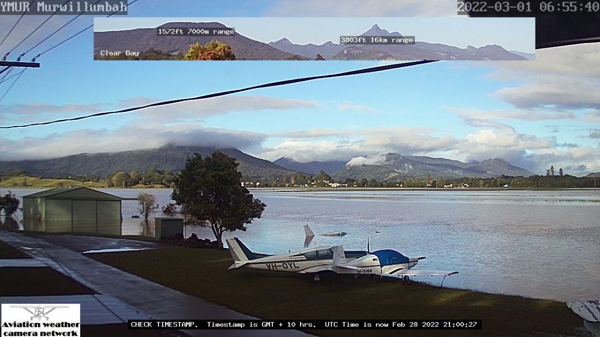
Here's the scene from Murwillimbah this morning... The first one here is definitely a Comanche, an earlier -250 now she's emerged from her swim. There's numbers on the side of her new-found friend so I still can't pick what it is, but it looks a bit like a KR2 or Morgan Sierra. The float-thingy is back on her feet, but the one in the mid-ground looks to be in a bad way... EDIT: Turns out these images in my above post will always be the current images from the weather-cam, so in days to come, they may well show bright sunny sky with nothing but green grass to be seen, hence why they are now the same as the photos in this post....The ones attached to this post were saved to my local drive and uploaded from there, so they will stay the same.

-
AAhh, gotcha. 🙂 We have one on our hangar but I never bothered to ask Brent how to go about accessing the archived images. AIUI they're stored on the server for 7 days.
-
how do you find the archives PF?
-
Looks to be going down slightly... At least ol' mates float-thingy is fairly watertight! I think that farther one is a Comanche but not sure what the nearer one is. Sad to see another one of those get written off. Though they are corrosion proofed from the factory, and it is fresh(ish) water....🤞
-
Were these ones flyable? Sounds like the floatplane wasn't quite there yet, and was the runway serviceable or waterlogged to the point you wouldn't have been able to get airborne?
-
I wonder if the homebuilt crowd is looking at the ever-reducing list and thinking "Bloody hell, I'm 18 months away from Phase 1, but I'll need a number, better grab one, any one, now!" . Seems to be going down around 12-15 a week, so could be less than a months worth of numbers left! IF CAsA do go to 4 letters, I'm reserving VH-FARQ. 🤪
-
75 on Friday... Makes me think about what Puzzle Palace will do when that number drops to single figures, which could well be by mid-year!
-
Spot on. I went up with an instructor a few months ago and one of the simulations was "You've just entered cloud, what do you do?", whereupon I promptly held then released the CWS button on the stick and simply said "That!" - though she seemed surprised as though she expected me to throw it straight into a 180* turn to get out. I explained we're above LSALT, the autopilot can fly the plane better, safer, and more smoothly than I can, and it doesn't suffer from spatial disorientation. In this example, the absolute safest thing to do is engage the autopilot, take a few seconds to think about what you need to do, change modes from ROLL HOLD + VS to ALT HOLD + HDG and then dial in your 180* turn rather than trying to do it yourself with bugger-all IF time and hoping it'll work out.
-
IF they say they are a FIFO Miner, or on the rigs or something like that, it is 100%, complete and utter bullshit - run away. Or play along, if you want to have fin... I work FIFO (when Chairman McClown allows me into McGowanland, that is) and off-site communications are A. Big. Thing. for the miners, because they have realised people (usually) want to talk to their families, or watch RedTube, etc and if they can't get that, they will go somewhere else. And recruiting a replacement costs a few quid... In a lot of cases, the internet speeds I can achieve in the Pilbara - particularly outside the evening peaks - rival what you can get at home. I'll often tell someone that I might be out of range when they call, but you can always get back to them when you knock off. The (very) few exceptions tend to be the likes of exploration personnel but even then, it's only a few days at a time, if that.
-
Yep, Google tells me it morphed into this one...More photos available if you google VH-XWS or "Smith FSRW" From the aeropedia website: Image courtesy of Aeropedia.
-
The biggest limitation IMHO for RWY on Android - for those who have a Dynon setup - is the inability to Wifi the flightplan from OzRunways to the EFIS if you make any changes on-the-fly. That's the only reason I still use an iPad - and probably the reason I'll have to upgrade to a "new" iPad in the not too distant future... 😞 I do most of my flight planning on SkyVector while having a cuppa, then just copy that plan into OzRunways and while warming up, send it to SkyView.
-
Just to prove it isn't always engine failure that can kill a Jabiru, one speared off the runway and into a hangar at Goolwa today while landing. 2POB enroute to the hospital with moderate injuries. I'm actually fairly impressed he's managed to get it between that other door outrigger &the water tank though! Images courtesy of the ABC...
-
 VH-WBL, a Jodel D.11.
 -
I think some of the RV's - particularly the -9's will benefit from an increase in value. I'm not sure a -7 or -8 will meet the stall speed at 760Kg - they're 44.5Kts at only 635Kg according to The Mothership, whereas a -9 is 43.5Kts at 790Kg. Perhaps some of the C150/152 series?
-
You're right, of course, about the lack of POH data, but what that means - to me at least - is you need to operate with the data you do have. Eg, the stall speed difference between F40 & F20 is 1KIAS (48 vs 49), & the balked landing procedure is to set F20 immediately after applying full power. So why not approach at F20, ensuring you can climb if you need to? IF you're flying solo and just come back from a XC with minimum fuel, then that's the time you can use F40 and can be assured of being able to climb in the landing configuration after a go-around. Using F40, two up, on a hot day is asking for trouble - as is trying T&G's on a short or otherwise performance-limiting runway. I tried to find an old DCA-approved C150 POH in the hope it would have "Australian-ised" performance charts with F40 landing climb weight limits, without success - but the absence of that chart doesn't absolve a PIC of the requirement to be able to comply with that CAO - which has been around for yonks, IIRC. To use the example given, a low-level 180, if you'd stalled & spun in, or hit the windsock pole halfway through the turn, the PIC would have been hanged, drawn & quartered, though the ATSB would likely find the lack of the landing climb weight limit chart as being a contributing factor, it's still the PIC's head on the chopping block.
-
Does that not put the PIC in breach of CAO 20.7.4 for trying to land at too high a weight to satisfy the 3.2% climb gradient requirement while in the landing configuration??
-
Pretty sure anything that is going to be used in C/E must have a [Position] Source Integrity Level of 2 or 3. From memory, the EC devices are usually only 1.
-
IIRC, the 787, A380 & A350 handle TCAS RA's with the autopilot now. I'm sure I read that somewhere, but do you think I can find it now? 😛 The whole "hemispherical levels" thing has a great get out of jail free card though: ^^That bit...I went from Broken Hill to Cleve, SA via Port Pirie a few days ago, and the highest available VFR level was 8,500. At Port Pirie, I climbed up to 10,000 for the over water portion across the gulf.. That gave me the ability to return to Port Pirie, or turn 90* and make it to Whyalla, or as I lost Whyalla, continue towards the runway at Cowell, ensuring I wouldn't have to go swimming if the noise stopped. I wouldn't have had those options at 8,500, ergo, 8,500 "was not practicable"... So long as you can justify why a VFR level is "not practicable", you're fine. Which is why I don't think ADS-B will be used for that kind of thing, besides, imagine the Civil Libertarians? "It'll start with aircraft, then they'll mandate it for vehicles, and no more speed cameras, every car will report when it goes over 100km/h!", and CASA would have a tough time proving your choice wasn't practicable in a court of law, IMHO...
-
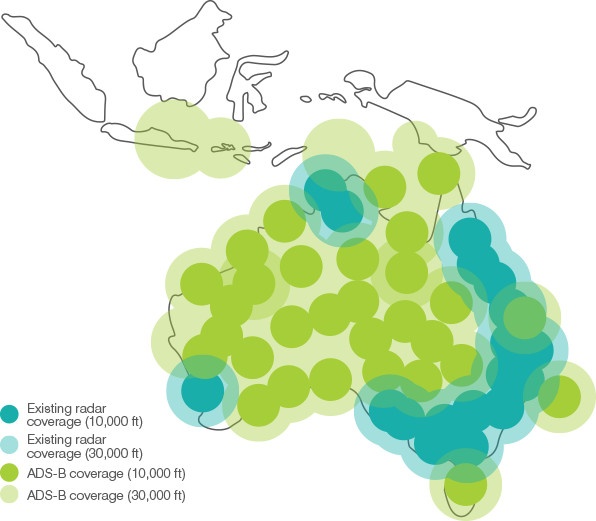
I know that. And if you honestly believe ASA has nation-wide radar coverage, I have this beaut bridge with a great view of the Opera House I'll sell you cheap. Here is the CASA ADS-B coverage map during the rollout of ADS-B in Australia, circa 2017. Green is ADS-B, blue is SSR. Get outside the J-Curve, Perth or the Tindal/Darwin area and there is no coverage! Which is why ASA+CASA mandated ADS-B in the NW region of WA years before the rest of the country - because they have heavy jets flying into multiple airports only 30NM apart, which absolutely zero visibility of where they are in relation to a potential conflict... This kind of coverage is precisely why ADS-B is great for those of us that fly beyond radar coverage. Not only does it show other aircraft where you are - but your missus or kids can track you to your destination using FA/FR24.
-
Yep, spot on. And that's the benefit of ADS-B over SSR-based traffic systems as, barring a relative few, "traditional" traffic systems used in GA required the intruder to be interrogated by SSR before generating an alert. No radar coverage? No traffic alerts.... ADS-B (and the glider version, FLARM) continuously tell the world "I am here, at X-thousand feet" - it doesn't care if anyone - or no one - is listening, it just keeps on keeping on. And, AIUI, the more advanced ADS-B systems can downlink your autopilot/FMS settings so ATC can confirm you have selected FL330 when he's cleared you to FL330. However, like the "ADS-B In" quandary of focusing on the screen, these are safety-of-flight messages and the GPS position must be accurate. That isn't a huge issue in and of itself with modern receivers, but certifying them as such is what costs lotsa $$ and why, traditionally, ADS-B has required high-end GNSS units. It's only fairly recently that the more enlightened NAA's have accepted that the likes of Dynon's GPS-2020 receiver are "good enough" and take Dynon's word of that, thus making them affordable for those of us with Dynon/AFS/G3X type systems. And let's face it, short of buying a 10(30?) year old mode-C unit, any transponder you buy these days is going to be Mode-S capable, so why not jut get a position source and be done with it? IF only for that once-a-year trip to the Birdsville races where you can have the security blanket of flight following keeping you out of trouble...
-
Absolute rubbish. 👎 There are very few Secondary radar's in Australia and even fewer Primary Radar's. Even ADS-B doesn't provide nation-wide coverage at GA altitudes. Hell, just today I flew from out west of Spencer Gulf, SA to the Hunter Valley (730NM) with Flight Following, at 9,500' and with a full ADS-B out setup - not a low-power EC device - around the SA/NSW border was told "Due surveillance coverage, identification terminated", and it wasn't until I was near Ivanhoe that I got "ABC, identified, verify level" and resumed flight following. You can confirm that yourself by checking the ASA ADS-B coverage maps. Nationwide radar coverage? Pull the other one... Now, FWIW, if you have a TSO'd GPS and a decent flightplan, I'm all for ADS-B, however, it will give an opportunity to ping you if you fly into a P/R area while on an evening jolly. The downside to ADS-B is, unless you have an aural traffic system, you can be drawn to the magic screen and spend more time looking for traffic on that than looking out the window. IT's a great tool, but like all tools, needs to be used appropriately.