Ironpot
-
Posts
186 -
Joined
-
Last visited
Content Type
Profiles
Forums
Gallery
Downloads
Blogs
Events
Store
Aircraft
Resources
Tutorials
Articles
Classifieds
Movies
Books
Community Map
Quizzes
Videos Directory
Everything posted by Ironpot
-
Not manslaughter: https://www.abc.net.au/news/2024-11-13/mcdougall-manslaugher-charge-dropped-fatal-plane-crash-qld/104596160
-
Cessna only just makes it to Bankstown 26/05/2024
Ironpot replied to kgwilson's topic in Aircraft Incidents and Accidents
Final report: https://www.atsb.gov.au/publications/investigation_reports/2024/report/ao-2024-033 -
consult the bible … er AIP: 1.1 General 1.1.1 Whenever an accurate QNH is available and the aircraft is at a known elevation, pilots must conduct an accuracy check of the aircraft altimeter(s) at some point prior to takeoff. Note: Where the first check indicates that an altimeter is unserviceable, the pilot is permitted to conduct a further check at another location on the same airfield; for example, the first on the tarmac and the second at the runway threshold (to determine altimeter serviceability). 1.4 Accurate QNH and Site Elevation 1.4.1 A QNH can be considered accurate only if it is provided by one of the following: a. AAIS; b. ATC; c. ATIS; d. AWIS; e. CA/GRS; or f. WATIR. Note: QNH contained in an authorised weather forecast must not be used for checking the accuracy of a pressure altitude system. 1.4.2 Site elevation must be derived from aerodrome survey data that is authorised in writing by either CASA or an NAA, or supplied in writing by the relevant aerodrome operator. 2.2 Area QNH 2.2.1 Area QNH is a forecast value which is valid for a period of 3 hours and normally applies throughout an Area QNH Zone (AQZ). 2.2.2 Area QNH Zones will be subdivided, if necessary, to meet the following standards of accuracy: a. Area QNH forecasts are to be within ± 5 hPa of the actual QNH at any low-level point (below 1,000FT AMSL) within or on, the boundary of the appropriate area during the period of validity of the forecasts. b. Area QNH must not differ from an adjoining Area QNH by more than 5 hPa.
-
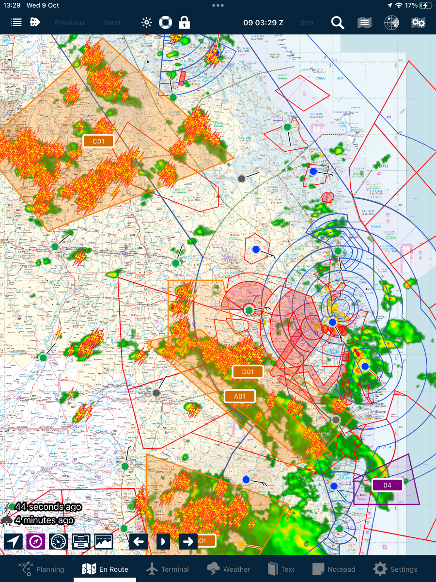
I just went to plan a flight. Lovely blue skies here but when I opened the EFB …. It’s TCU CBs, thunderstorms with moderate rain. I’m not saying that I wouldn’t have looked at the GAF and ATIS prior but it’s so good to see it instantly.

- 1 reply
-
- 1
-

-
I dunno. I don’t know the guy but this is a 2000 hr pilot; 1500 in this aircraft. Top of descent, 20 miles to run, 5500 to descend … I think he’s in front of the aircraft. And then …. the aircraft exceeds VNE??? I don’t think that incapacitation can be ruled out so easily.
-
If it’s the right aircraft and it’s suitably equipped ( autopilot?) it’s not a problem.
-
Overflying Maree Man is on my bucket list.
-
William Creek is well worth a visit.
-
Mangalore incident today (19/2/2020)
Ironpot replied to biggles's topic in Aircraft Incidents and Accidents
Yep and that’s what he was attempting to do. https://www.atsb.gov.au/sites/default/files/media/5781079/ao-2020-012-final-3.pdf I have to admit that I still don’t know what I would have done differently had I been in the left hand seat of either of these two aircraft. Maybe look to better understand the intentions of traffic. Where I fly we generally have RPTs to contend with but it’s just a case of listening out, let them know your intentions, and then allow them plenty of room/time. -
Mangalore incident today (19/2/2020)
Ironpot replied to biggles's topic in Aircraft Incidents and Accidents
ADSB - in is great. You see everything that is suitably equipped out to 50 miles. I often get alerted by ATS to aircraft on reciprocal track “ … ABC is in your 12 o’clock 1000 above/below and will pass you in x minutes” However, with all that technology, I’m amazed at the number of times I don’t see a kingair or aerocommander even when I know exactly where to look! -
Light plane crash south west of Sydney 24 Jan 2024.
Ironpot replied to red750's topic in Aircraft Incidents and Accidents
ATSB report. So bloody sad. https://www.atsb.gov.au/sites/default/files/2024-07/AO-2024-002 Final report pdf.pdf -
Deano; does the tower give “caution, wake turbulence “ ?
-
ATSB report on Cessna 182 crash Qld 29 Aug 2022.
Ironpot replied to red750's topic in Aircraft Incidents and Accidents
No it wasn’t me. Could you edit that one please. -
ATSB report on Cessna 182 crash Qld 29 Aug 2022.
Ironpot replied to red750's topic in Aircraft Incidents and Accidents
Apologies I didn’t want to cause a debate on LSALT. Like everyone else, I try to learn something from these reports and take something a way that I can use, should I find myself in a similar situation. My personal solution will not work for everybody and l’m not suggesting non-instrument rated pilots even think of using this! Climbing to grid LSALT was 5200 (10 nm Amberley would be better and that’s 3400) but this guy would still be in cloud, and copping flak from ATS but on Autopilot and safe. ATS would’ve had him on radar and vectored him to safety somewhere. That’s what they are there for. I can’t imagine the shit he would’ve copped afterwards. But he was retiring 2 months later! Hey ho! -
ATSB report on Cessna 182 crash Qld 29 Aug 2022.
Ironpot replied to red750's topic in Aircraft Incidents and Accidents
It is important! I think you forgot NVFR!!!! The illustration should be 10 miles left and right of track and it’s only applicable if you’re TSO’d GNSS equipped; otherwise you have to calculate lowest safe by reference to the aids available. In practice, I think this pilot would be aware of “Grid” LSALT as shown on the ERC (not the VFR) chart. So just switch to ERC on your iPad/tablet and the big blue number indicates the LSALT for the grid square that you’re situated. -
ATSB report on Cessna 182 crash Qld 29 Aug 2022.
Ironpot replied to red750's topic in Aircraft Incidents and Accidents
Condolences to the families and apologies for any distress this discussion may cause but the Aviation community do need the discuss this accident. That’s not the full story - he held a MECIR and had 8 renewals. He knew how to fly on instruments in an emergency. Furthermore the aircraft was IFR approved and had an autopilot. He had the latest TAFs and METARS and maybe somewhere abeam Toowoomba he knew it was time to climb to LSALT, talk to Amberley Approach and declare a problem. Was this just a case of “ hold my beer”? -
Council have voted to continue use and are actually going to spend some $s on maintenance
-
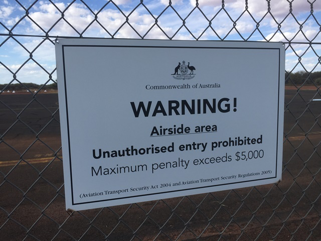
Expensive cup of coffee! But, in the real world, and say you were flying a real flight - if you had left the airport, just how would you have flown away, had you, let’s say, left the confines of the airport?
-
Which airport is that?
-
Mods, this is getting a bit silly now! We all know that young students and the general public (maybe CASA too) read these forums and rely on, what they hope, is genuine experience. We all know that pilots require a valid background but that is not being conveyed here. We now have a poster encouraging pilots to break Australian Federal Law by walking through hangars and avoiding security fences without the appropriate security clearance - clearly this forum, at the vey least, cannot support any such cowboy behaviour amongst pilots. At the worst, in the event of a safety incident, the forum may have some liability and clearly these views should not be condoned.
-
Sure, ring ahead if you are enquiring about fuel. But I don’t know of an ARO that will give you the gate code without seeing your ASIC. They might just say it’s the CTAF if it is … maybe? My point is that, more than likely, your security for your very valuable “pride & joy” relies on an ARO doing his job properly whilst you are away. They shouldn’t be allowing anyone on a Security Controlled airfield without an ASIC. It’s a form of security for your aircraft and pretty cost effective when you think about it. We have one guy on here from Longreach - last time I was in Longreach I had to hold my ASIC up to the camera BEFORE I could LEAVE through the gate and I was bursting for a piss! The ARO is sat in his office 50 yards away! We have another guy on here from Mackay - the ARO there is next to the door of the aircraft as soon as you shut down (Brandon?) Lovely guy, and he wants to see your ASIC straightaway. Then he gives you a card with the current code in exchange. So, if you just want to do circuits around your home paddock then you certainly don’t need an ASIC. But if you want to fly somewhere where you can wander into town and then you have to get back through the gate on your return, then you do need an ASIC. The batshit crazy, MAGA type sovereign citizens raving on here probably don’t fly in the real world so pay no attention to them.
-
Sure sure and you probably tie the aircraft down too. But do you never make contact with the ARO when you park-up up at an airfield? Do you just walk out the gate without talking to anyone? If so how do you get the gate code if it’s not displayed?
-
Serious question: when you park up at an airfield and before you head into town, say Bundaberg for example, exactly how do you secure your aircraft?
-
My 2 bobs on this one: It’s really handy to see traffic on the iPad and cos the 2 systems don’t share data its something else to decide upon. It appears to me that QzRunways is most popular amongst the amateur community, i.e. RAA, smaller GA etc. Avplan seems to be standard issue amongst the RPT, RFDS and bigger GA guys. It may simply be a cost thing but because the 2 EFBs only show their own subscriber traffic you don’t see the other guys on the display! I understand Avplan have offered to share but OzRunways have refused to do so. So, maybe, if you normally fly VFR below 4500, you might see more on OzRunways but if you generally fly IFR or cross-country then Avplan might be better for you. In a bid to keep everything as simple as possible, all my gear is now Apple cos it talks to each other and it just works straight out of the box. I use a standard iPad, 32 Gb (no card) a mini, 64 Gb, as a backup (again no card). An iPhone serves as a hotspot in the air - I generally use an Optus connection but have access to a Telstra one if I'm heading outside the J curve. A Garmin Glo provides GPS signal. I fancy an iPad pro next. I find the mini is just too small and awkward for general use (it’s great as a backup and I’ve needed to use it in anger 2ce - the iPad will overheat if you leave it charging in the sun.
-
the meaning of the initials qnh
Ironpot replied to BrendAn's topic in Student Pilot & Further Learning
UK Military always taught that QNH is Q “Newlyn Harbour”. ( Newlyn Harbour is where zero sea level is calculated from for the UK based on the observations taken there for many years) QFE is Q Field Elevation