

APenNameAndThatA
-
Posts
1,414 -
Joined
-
Last visited
-
Days Won
5
Content Type
Profiles
Forums
Gallery
Downloads
Blogs
Events
Store
Aircraft
Resources
Tutorials
Articles
Classifieds
Movies
Books
Community Map
Quizzes
Videos Directory
Posts posted by APenNameAndThatA
-
-
On 12/05/2021 at 8:39 AM, Garfly said:
You don’t know how cloth got in your engine? Maybe whoever last rebuilt it knows?
-
I prefer that software works properly.
-
35 minutes ago, John Robert said:
Quote
"At the moment, I am opposed to Chinese cars because the Chinese want to take over the world." end of quote
Where did you get such a racist opinion?. Have you visited China, do you know much about its history?.
So many Australians have been turned against our most important trading partner by a media dominated & controlled by the US.
A few facts, China with the largest population in the world was a basket case only 50 years ago.
India with a similar population but a democratic system was in a more advanced position at that time.
India is now a 3rd class country with a millions of people living in extreme poverty.
In the last 50 years China has come from a really poverty stricken 3rd world economy to be close to the US in
technological capacity.
Their citizens have a much better standard of living & future than their neighbours in India & their standard of living
will equal those in the US in the not to distant future.
There education ensures that all students get the benefit of free education to the limit of the students ability.
They may live in huge blocks of flats but there are fewer homeless than in the US.
They have never threatened other countries or invaded them in our era. Even in the past they built a huge wall to
keep others out.
They will replace the US & be the world leader in technology & trade.
The US is the most aggressive country in the world. They have in 70 years killed more innocent civilians &
destroyed more homes & infrastructure than any country in the history of the world. In a desperate attempt to
stop the spread of communism. In that time they have never been able to change the direction of the people they
invaded.
They have applied sanctions on numerous countries simply because they do not like their political system.
They have threatened countries for purchasing arms from competitors.
The political system in the US is a basket case, They have no universal health system,
University is for those who can afford it not for those who qualify.
They have even interfered in the Australian political system. (removed Whitlam)( read the historical events)
The US government are currently paying private phone companies to remove 4G Huawi equipment. Its costing over 1 Billion for the 1st stage. They have no universal health system & extensive poverty & homelessness. There hospitals were using plastic bin bags for protective equipment a few months ago due to lack of funding. They would rather try & spite China than look after their own population. I Billion would buy a lot of protective gear.( There was never a known security problem with the 4G equipment.)
The above are facts.
The Tesla Cars built in China are reputed to be of a higher standard than those built in the US. My only experience with an American SUV was a Ford Explorer, 12 months after purchase I saw underneath when it was on a ramp for service. It had so much rust that it appeared to have been living in the ocean. At that time the Ford Explorer had zero underbody protection. I mean ZERO, not even paint. It took much complaining & threats but eventually Ford had the fuel tank removed & the whole underbody sand blasted & painted. 5 days later I had a near normal SUV.
I have spent 4 weeks travelling in the Southern States in the US, 3 weeks the length of Russia & 3 weeks through China.
So sad to think of the millions of decent hard working people of all races who will die if we ever have war.
If it happens it will not be China that starts it as they only have to be patient to replace the US as the number1 world power.
Calling me racist was a jerk move. You wrote a lot but very little was about whether or not China wants to take over the world.
In fact, in our era, China has invaded Tibet, Korea and Vietnam and had border clashes with India and Russia. It has bern in conflict with Japan over islands. It has invaded the sea space of lots of Asian neighbours with the nine-dash line in the South China Sea.
The belt and road initiative is designed to, amongst other things, control other countries through debt.
With China’s wolf warrior “diplomacy” has been a disaster for them. They could have quietly gone and bought the world, so to speak, but showed their hand ranting any time someone criticises them.
You wasted a lot of time saying how great China is compared to the US and India. I agree with those comments, but they don’t contradict my point. To return to calling me racist: kindly demonstrate that my comment was racist or retract the allegation. It is very poor form to accuse someone of racism when they are not racist and have not done anything racist. China and Taiwan have basically the same ethnicity, but China is basically saying that they will invade Taiwan, another place they intend to take over. How can I be racist against Chinese when I fear for Taiwan? Same race, genius.
-
 2
2
-
 1
1
-
-
HF probably stands for HF Area I suppose.
OzR said they will add info to the docs. That is the advantage of whinging instead of being resourceful and stoic.
-
On 21/07/2021 at 5:06 PM, Garfly said:
By the way, does HFA refer to HF radio comms ? So you have a HF radio in your aircraft?
If so, might this help?
No I don’t (I know). But the HF frequencies are in the Planning Map and the ERSA, both of which are in the app.
-
Wow. Classic latent error material right there. I thought that notams were displayed in chronological order. Were there 57 more recent notams?
-
16 hours ago, F10 said:
I largely agree, but I think one important factor you left out, I remember when all the Taiwanese made tools were cheap….and junk. It took a few years but now they are as good as the best. I don’t like Chinas government and would happily support its removal or democratisation, but one thing is some Chinese goods are just that, good. I’ve owned a small Chinese made CFMoto little commuter motorcycle. It’s done around 25 000 Kms trouble free and still looks brand new at 5 years old. I bought my wife a Haval H2. SUV. At the time, nothing came even close spec wise, for the price. Took a punt. Had it for four years and it’s been fantastic we love trips in it. Chinese junk….not really anymore. It’s an interesting situation.
Hyundai cars used to be awful. Now, I actually think that they are a little bit actually cool. It's like they are the new Holden, and Nissan and Mitsubishi are a bit yawn. I am biassed. But I enjoyed driving my Hyundai i30 more than the more expensive more refined Mazda 3. The main thing was the seats were more comfy.
At the moment, I am opposed to Chinese cars because the Chinese want to take over the world. But it is good to know that your Chinese stuff has been going well. Motoring writers emphasise handling and what not. They can't understand (for want of a better word) why the Hilux is more popular than the Ford Ranger. The reason is reliability.
-
-
On 21/07/2021 at 8:55 AM, Munger said:
Morning All,
In the Northern Rivers of NSW, we have a situation that is close to every aviators heart: Local council having a go at aviators because we are an easy target.....
ONE aircraft noise winger (Judith Forsyth), who moved to our community about a year ago, has managed to get into the ear of a few councilors and now the whole airport and peoples livelihoods could go up in smoke.
Izaac from Fast Aviation has put out a petition with a very detailed description of what is going on to assist business at Lismore Airport and taking aim at the ridiculous landing fees.
The link is:
If you are unimpressed by the way Lismore City Council is administering the district, or simply sick and tired of the abuse we cop from aircraft noise lobbies, please consider signing it and passing it on to as many people as you can.
Andy
From what Turbo said, you need to get competent legal advice ASAP and before you do anything. In my limited experience, you need a senior lawyer, with the right expertise, who really does know what they are talking about. Also in my limited experience, if you get advice from the lawyer and proceed on your own, your fees are reasonable. If you get the lawyer to go off and do things, or, worse still, have people communicate with the lawyer, fees get stupid and utility deteriorates fast.
-
On 21/07/2021 at 9:33 AM, turboplanner said:
Andy, this is a planning issue so you would need to check what exactly is happening.
An individual making a lot of posts on FB has no impact on an Airport
If the person is putting up a Planning Amendment to change the Use of the airport, you need to respond.
If the Airport has Existing Use Rights under the Planning Sheme, that's usually the end of any proposed change; aircraft make noise.
Beware of any invitation by the Council to take part in any "Operating Policy", " Precinct Plan" or one of a million other words where the owner/operator is asked to participate in consultations for the adoption of the Plan, because if you do you give up your watertight Existing Use Rights. If the owner and Opertor of the Airfield are unsure of what is happening they should hire a planning Consultant.
If what you say is true (and it sounds it is) this could be the most important post on this site ever.
-
1
-
1
-
-
The issue was that the data could not update. My login details were rejected. When I logged in, after some difficulty, OzR went back to functioning normally.
BUT
I didn’t know about tapping and dragging on the box like you mentioned! Which is interesting. It would not have worked, I expect because the problem was related to my log in credentials.
OzR support did not mention what you mentioned. I believe that the software is supposed to update every time you open the program. That is what has happened every time before and since.
AND
You are not the first person who has told me I overthink things.
-
 1
1
-
-
On 18/07/2021 at 6:53 PM, Garfly said:
Well, yes, mine works properly but it seems my expectations are very different to yours.
I don't really understand why you are so focussed on that particular - scarcely necessary - special feature (i.e long press to bring up list of airspace overlays). I've never bothered with it much, myself, because it's mainly there for the benefit of professionals boring holes in the flight levels. The only item of interest to us, as far as I can tell, is the last one on the pop-up list, the FIA station/frequency for that area. But there are other ways to keep track of that info anyway. (As discussed above.)
In any case, I'd have thought it almost impossible for any mapping app to give you what you seem to want; how can a complex inverted wedding cake structure be illustrated by a single top-down, layer-view alone. But then, that's what the charts, themselves, are for - and why we learn to decipher their secrets. All the information you seek is on them - or, if not, in ERSA, AIPs, CAAPs etc. - and, as it happens - all of those resources are right there, at our fingertips, in the app. What's not to love? What's more to want?
Actually, if you experiment with Terrain View you can, indeed, have your flight-path represented as a side-view, as you negotiate a safe path between terrain below and airspace above. But features like this are all just nice to have extras, which proper planning (and a bit of good luck) most of the time, obviates the need for.
To me a really great feature is the real time display of PRDs; those which are active and those that are de-activated (represented by a pink overlay). It needs internet access but when it's working it can be a big help for anyone traversing complex prohibited airspaces. Needless to say, double checking with Centre and/or Notams is always prudent. (Did we mention the Notams accessible via SmartBrief? ;- )
I guess I just don't understand what you want and expect from the app. I, for one, am pretty happy with what the software-geek/pilots at OzRWYs and AvPlan are doing to make our aviating less stressful and more safe. And, to tell the truth, it strikes me a little tough to bang on about Great Circles and Rhumb Lines. Maybe I'm missing something but I can't say it's a problemo I've ever faced. But then the Skyranger runs out of puff well before the flat earth starts into curving a lot.
Anyway, good luck with your trip; good that compass, map and clock - which, I gather, you're actually planning to use - still works well, in case you still can't get no satisfaction. ;- )
Actually, on the subject of documentation, I thought that if I could not tell the difference between CTR and CTA then that was on me because I don’t know enough about flying. On reflection, I am in Australia, and two of the acronyms were not used in Australia. That means that there was no source that I could go to to look up the meanings. The meanings will/ differ depending on what country you are in. That means that the meaning of the acronyms should have been in the documentation.
-
1
-
-
On 18/07/2021 at 6:53 PM, Garfly said:
Well, yes, mine works properly but it seems my expectations are very different to yours.
I don't really understand why you are so focussed on that particular - scarcely necessary - special feature (i.e long press to bring up list of airspace overlays). I've never bothered with it much, myself, because it's mainly there for the benefit of professionals boring holes in the flight levels. The only item of interest to us, as far as I can tell, is the last one on the pop-up list, the FIA station/frequency for that area. But there are other ways to keep track of that info anyway. (As discussed above.)
In any case, I'd have thought it almost impossible for any mapping app to give you what you seem to want; how can a complex inverted wedding cake structure be illustrated by a single top-down, layer-view alone. But then, that's what the charts, themselves, are for - and why we learn to decipher their secrets. All the information you seek is on them - or, if not, in ERSA, AIPs, CAAPs etc. - and, as it happens - all of those resources are right there, at our fingertips, in the app. What's not to love? What's more to want?
Actually, if you experiment with Terrain View you can, indeed, have your flight-path represented as a side-view, as you negotiate a safe path between terrain below and airspace above. But features like this are all just nice to have extras, which proper planning (and a bit of good luck) most of the time, obviates the need for.
To me a really great feature is the real time display of PRDs; those which are active and those that are de-activated (represented by a pink overlay). It needs internet access but when it's working it can be a big help for anyone traversing complex prohibited airspaces. Needless to say, double checking with Centre and/or Notams is always prudent. (Did we mention the Notams accessible via SmartBrief? ;- )
I guess I just don't understand what you want and expect from the app. I, for one, am pretty happy with what the software-geek/pilots at OzRWYs and AvPlan are doing to make our aviating less stressful and more safe. And, to tell the truth, it strikes me a little tough to bang on about Great Circles and Rhumb Lines. Maybe I'm missing something but I can't say it's a problemo I've ever faced. But then the Skyranger runs out of puff well before the flat earth starts into curving a lot.
Anyway, good luck with your trip; good that compass, map and clock - which, I gather, you're actually planning to use - still works well, in case you still can't get no satisfaction. ;- )
Well, one of the reasons is that I am using the app backwards. That is, using the airspace function to teach me about airspace. I figure, if there is an acronym to do with airspace then I should know what it means. None of the meanings of the acronyms were explained in the documentation. It turns out that two of them are not even used in Australia.
As for what I am interested in, I need to be able to see any airspace below 10 000 feet that is not marked on the hybrid visual map. That means that I need to be able to see Class FIA and a little Class E. I need to be able to see controlled airspace but that is on the hybrid map (except for a little around Alice Springs!).
I also don't think that it is too much to ask that the documentation contains the following, that support sent me.
CTR is the zone, that goes from ground level.
CTA is the other controlled areas.
TMA is not used in Australia
ATZ is not used in Austrlia
My HFA still does not work. That is a genuine bug. Also, the HFA does not state the frequency that is used.
In some ways, my expectations are actually LOWER than the developers. They have put things in that I would not have worried about and some of the things are broken. I didn't ask for rhumb lines vs great circle lines. They did that themselves and it was broken! Also, they have made a classic software developer mistake of putting out new versions before they have fixed the bugs in what they have already produced. That causes what developers call a tech debt. That is, you already have bugs, and then you add more features, you are likely to produce more bugs, have even more bugs and have things harder to sort out.
OzRunways has another bug that I did not mention to you. I submitted a flight plan (I got an email back to say that it was successful) but the weather a) had not updated and b) had not said that it had not updated. I was looking at the Smart Briefing as if it was today, but it was from several days ago. If I had not checked the dates, I would not have known. That is actually a dangerous bug. So, I am a very junior pilot and I have found *three* *actual* bugs in the software. That is not good. There are probably more.
-
1
-
-
18 hours ago, Garfly said:
Sorry, I don't understand the problems you're having at all.
But I'm sure the support team will get back to you on them.
So yours works properly?
-
18 hours ago, poteroo said:
Never tell CASA that you are losing filthy money due to delays - their charter does not cope with that! It's like a red rag to a bull.
My flying instructor might have just got lucky then🤷♂️
-
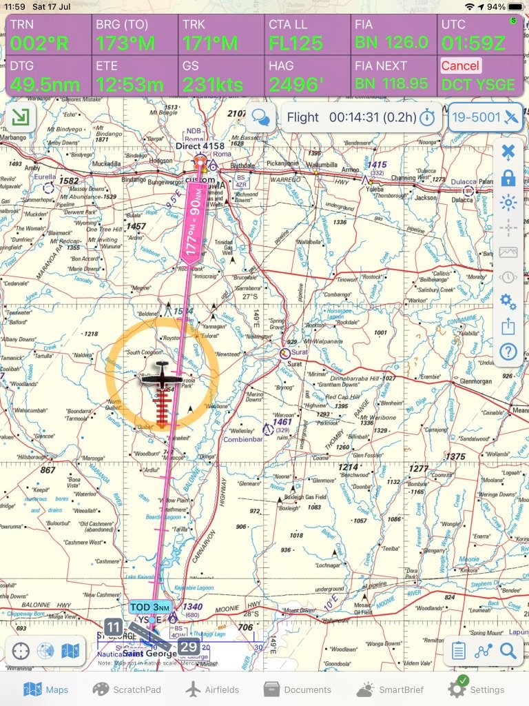
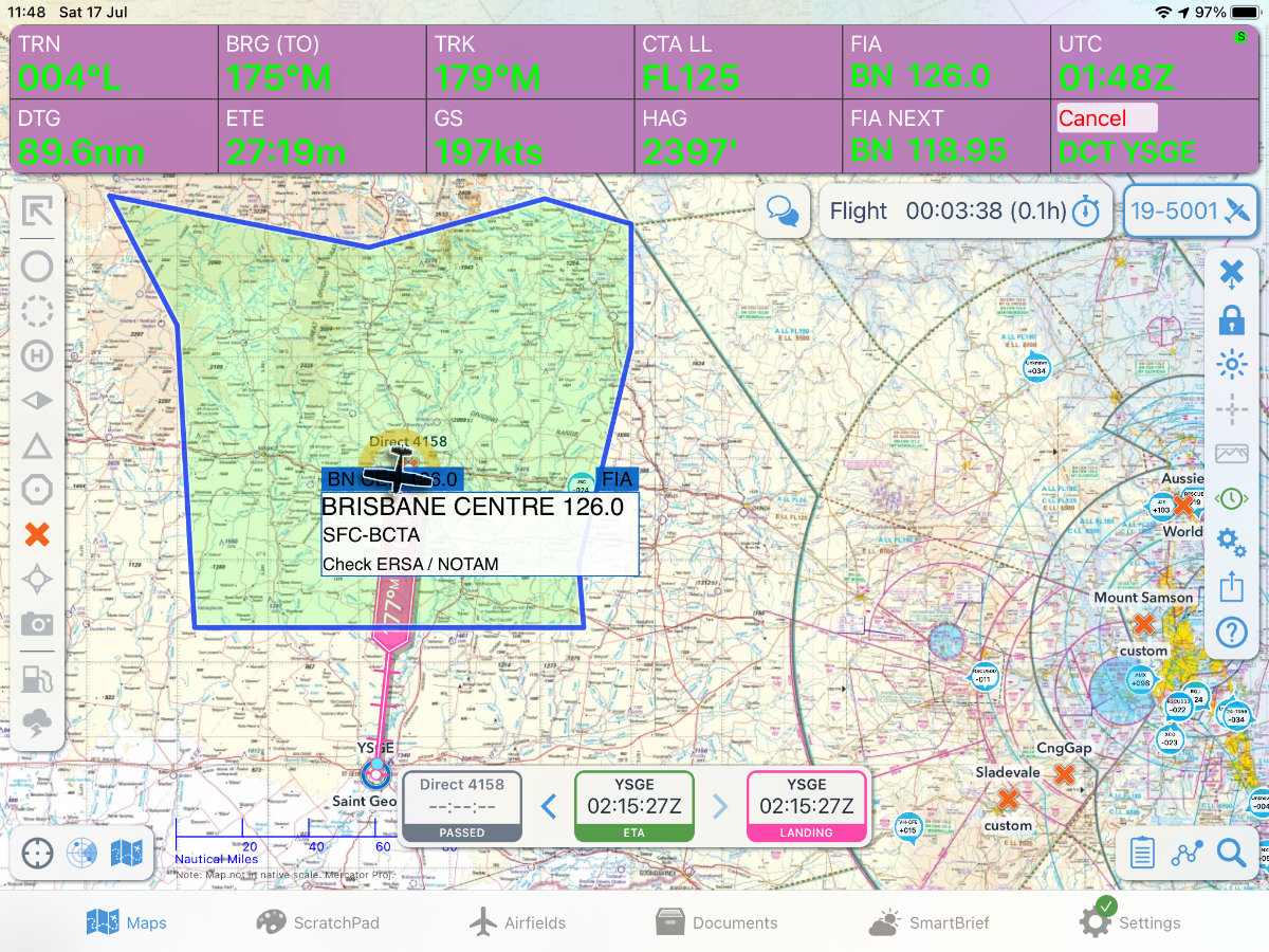
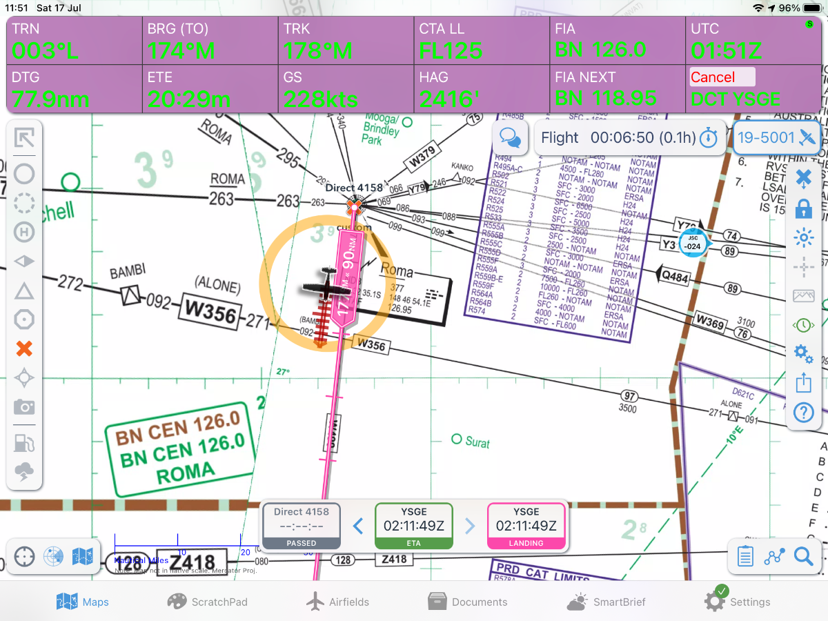
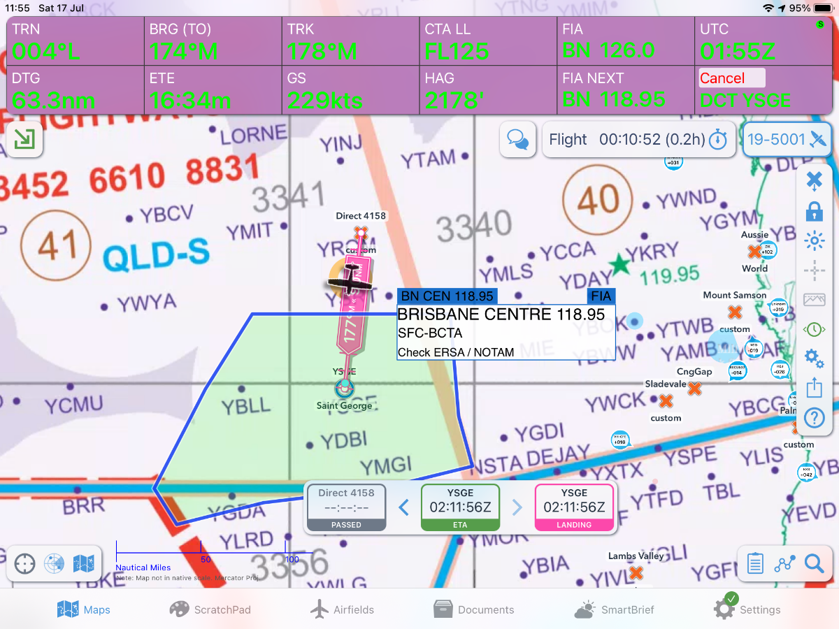
As you know, if you long press on the/a map, a list of airspaces at that point show up. If you select one, the boundaries of that space will be shown on the map. Contents of email I just sent to OzR is as follows. Pls correct me if I am wrong.
Please tell us about your experience with OzRunways:As you know, you can long tap the map and get the option to display the boundaries of the airspaces at that point. My concerns are as follows.1. The documentation does not say what selecting the different spaces will display.2. I am not surprised because embarrassment because of the following3. CTR should display C and D, but hardly displays anything4. HFA does not display anything. And it’s for emergencies!5. ATC seems to only be high6. TMA displays nothing7. ATZ displays nothing8. There is no option to only display areas at or below, say 9900 feet AMSL.9. You should tell people who are unsure to also tick EFREQ and FIA.Also, I told you a year ago that your great circle distance returned the same distance as the rhumb distance and you still haven’t fixed or ‘disabled’ the feature. -
2 hours ago, Garfly said:
Maybe this trip-plan from Roma to St. George shows better an area only covered by WACs.
You can have the app display the boundaries of the current FIA on any installed map. Your ERC Low National and Planning Chart (PCA) - with the course line drawn in - are only a click away, if you wanted to check where the FIA transmitters are located, for example.
But in the olden days, yes, WACs often had all kinds of airspace info pencilled in on them including Control Zone wedding cakes etc. But at 1:1,000,000 scale it was never their job to keep up with ever changing airspace changes. They typically weren't updated for many years whereas VTCs etc could change every few months. Thank goodness we can now all have every conceivable chart at our fingertips - reconciled to any and every scale (for the whole world, for that matter)and guaranteed up to date.
Again, these 'thumbnails' look huge but you need to click on them to see them properly.

Thank you! I had no idea you could display the FIA boundaries over the WAC in Oz Runways!
-
So, I will be using WAC’s. As far as I can tell, I will need to transfer the Brisbane Centre frequencies from the low level planning map to the WAC (maybe with a green Sharpie), indicating the pink and purple coverage areas from the planning map (maybe with a brown Sharpie) and writing the AERIS frequency here or there.
As personal preference I will be marking some aerodromes/ALA’s with elevation, circuit height, CTAF, runway orientation, any right hand circuits and any AWIS.
So, how come WAC’s don’t have frequency boundaries and radio coverage marked on them?
Also, is it obvious which centres have the transmitters for Brisbane Centre if I inspect where the centre of the pink circles will be?
Also, also, is there some chart about that already shows the boundaries of the Brisbane Centre frequency areas on it? It would help if people knew when to change frequencies, although iPads probs fix that issue now.
Thanks!
-
 1
1
-
-
2 hours ago, poteroo said:
Was told by Avmed 3 weeks ago that I'd better relax and chill - they were looking at 6-8 weeks to process a Class 1 or 2, (with conditions applying). After several requests for ever more detailed reports, my grounding has now run out to 16 weeks. Just when we had more students thru the door than in the last 15 years! Time to retire, methinks.
not so happy days atm.
Apparently, if its important you can get them to speed it up. Like, if you can’t work.
-
So, CASA decided to big note themselves by postponing pilots needing to submit medicals. Consequence a) the postponement cones to an end, causing consequence b) they get a rush of applications, causing consequence c) above. Aren’t managers supposed to think ahead?
-
1
-
-
I’ve been within 30 m of another aircraft… twice
-
2 hours ago, skippydiesel said:
Oh goody!!!we have a debate ;
- I say ALL precipitation is part of the cloud it comes from ego you fly through precipitation (light or heavy) you are passing through cloud (light/heavy)
- Further - I also say precipitation can not fall from a clear sky (there must be a cloud somewher even if not directly overhead the reciprocation).
Lets go to it chaps!
You are going to have to cop the losses on this one. RA-Aus aircraft are allowed to fly in rain, and can thereby get airframe icing. If rain was cloud, VFR pilots would be required to remain clear of rain. It isn’t and we’re not.
-
1
-
I found this amazing.
I will try and embed a video.
-
5
-
1
-
-
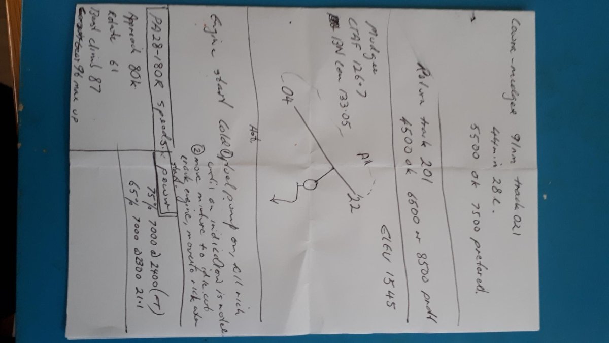
On 01/07/2021 at 11:37 AM, Thruster88 said:
I use a tablet for every thing and produce a simple hand written backup.
Recent flight to mudgee, starter failed to work for the return journey 😬
I think I’ll add course and distance to my summaries, as that will give me the basics while I get the paper map out.
vertigo and queasiness
in Student Pilot & Further Learning
Posted
I used to even get sick on commercial flights and overcame it. I started off by playing games on my phone as a car passenger. That got me used to the decoupling of acceleration with visual input. It will stop you associating the airplane with feeling sick. Thrill rides at theme parks are another option. I spent 2.5 months going to Dreamworld to overcome my fear of stalls. I could help with airsickness too.