

APenNameAndThatA
-
Posts
1,414 -
Joined
-
Last visited
-
Days Won
5
Content Type
Profiles
Forums
Gallery
Downloads
Blogs
Events
Store
Aircraft
Resources
Tutorials
Articles
Classifieds
Movies
Books
Community Map
Quizzes
Videos Directory
Posts posted by APenNameAndThatA
-
-
Downloading the app = endorsing Scomo's lies (to me). So, no.
-
 1
1
-
 1
1
-
-
With flying training disrupted we still have many folks flying about in light aircraft. Who's watching the smaller airfields for sneaky folks crossing the borders while states are in lock down?
I thought that flight traning was still perfectly legit?
-
Just very lazy, the curse of my generation.
tend to lose the proper grammar and ignore spelling when it comes to the internet.
English obviously first language.
-
If you were taught to fly your downwind leg with the destination strip/runway 'cutting' the strut or aileron/wingtip at a set point - then it doesn't really matter, (from your flying point of view), whether you are a couple 100 feet high/low: your aircraft will be in it's correct position in relation to the strip/runway. Get your head out of the cockpit and watch for the correct visual cues in your flying, and stop stressing over what an inherently inaccurate instrument reads.
happy days,
I thought it could matter a lot. If someone was 200 feet high in the circuit and someone was 200 ft low overflying, then they could collide. Also, if planes in the circuit are not at the same height then it will make collisions more possible, especially as two planes that have not seen each other are approaching the threshold. Disclaimer: I have 50 hours.
-
Passed my ride thanks to some of the answers here. Thanks.
-
1
-
-
Stop it, there you go thinking again................................................................Just fly the aircraft

I'm with Nev on this one. Thinking this through is not overthinking at all. It is important so that you know not to use ground speed as a proxy for airspeed.
-
P.S. You can also use the removable sticky tape to sticky tape shut the bits of the map that I was not going to need. Apart from that, I was just using the standard sheet with the headings and times, and a couple of checklists, especially the clear off checklist.
-
I managed to pass my nav flight, so I thought I would share some of my tricks - some of which came from here. I used removable sticky tape to write colour-coded cues for radio frequencies, altitudes, radio calls and transponder/ATIS/QNR and pre-landing checks. I drew five mile circles around all the aerodromes, and five and 10 mile circles around the aerodrome that I intended to land at. That prompted me to notify aerodromes when I was passing close to their pattern, and do landing checks (five miles) and do approach calls where I was landing (10 miles). By doing the call at exactly 10 miles, ETA = T + 7, in my plane. I also coloured the border of the different maps with different highlighters. That enabled me to get the correct side of the correct map easily.
For my destination airport, I wrote the elevation, circuit height and overflying height, CTAF, runway names, and if the circuit was left or right (S or Z - shaped) so I could picture the runway names and dead side as I approached the aerodrome to overfly it. With the heights all written down, I would not have to do maths under pressure. I must say, none of this info is presented this way on electronic displays, so at the moment, I plan on using paper maps for navigation and GPS just to confirm my position. All comments welcome, and the more critical the better - negative feedback is valuable.
-
3
-
-
It’s all propaganda. All you ever hear about is how great bees are. Turns out they’re idiots.
-
2
-
-
I would try and get my money back. If you can't, then wait and see.
-
1
-
-
My A5 knee pad has a couple of transparent plastic sleeves that can contain checklists. I *love* the transparent plastic sleeves. And the pockets hold a wizz wheel and protractor/ruler and pens and pencils.
-
What I have taken from this discussion is *highlighter tape*. It is not at office works, but transparent, removable sticky tape is. So, I will be able to write on my chart in different colours of permanent marker, and then remove them after the flight! (I will continue with the PPPPPPPPPPPPP, writing on the map, and writing on the flight plan) Thanks! Highlighter tape is on Amazon.
-
1
-
-
-
Good points. PPPPPPPPP, marking on the map, marking on the flight plan. Thanks!
-
If you are navigating properly instead of just following the line, you will know exactly when you are crossing a frequency boundary.
As I am learning, I don't use GPS at all.
-
1
-
-
Hi. I have done about four LSA navs so far. I keep forgetting when to change the frequencies. Possible solutions that I can think off is to do the CLEAROFF check every couple of mintues and marking on the map in advance when to change to what frequency, or putting it on the flight plan where you mark down your altitudes and headings. Ideas? (CLEAROFF, in case you use a different acronym, is
C Compass: DG
L Log: ETA, ETD, SAR
E Engine gauges
A Altitude: QNH, plan, cloud
R Radio frequency
O Orientation (location)
F Fuel: amount and tank
F Forced landing spot)??
-
1
-
-
After reading your replies on several threads turbo, I'm convinced you have NO IDEA what an EFB is and what it does....
To the task at hand. I keep an A5 sized board onboard. Great for random notes and rego's....
I think that what Turbo is saying is that if you just follow the magenta line, you will not have a clue when your fuel will run out, if you are in controlled airspace or what frequency you should be on.
-
The chopper pilot was simply a complete idiot. Fancy flying around blind in California mountains, in a California fog! I cannot understand the stupidity of the mindset of some people.
It's the same dumb mindset as people driving along roads in thick fog at 100kmh with visibility at 10 to 20 metres.
The same dumb mindset that caused the $30M cost of the Lismore truck-train crash in 2006, when the Kenworth driver drove his loaded rig into the side of 3 locos at 90kmh in thick fog.
Yeah, but he actually wasn't a complete idiot. And he still did something idiotic.
-
I read horror stories about people improving on the factory design of fuel systems. Disclaimer: my engineering experience is that I once built a treehouse.
-
You can be as certified as you want but that won't keep you safe in fog in a helicopter in hills, as someone else implied.
I think that celebrities need to understand that people get star struck and turn into idiots. It should not be the case, but it looks like it is that case, that celebrities sometimes have to be the one to say "no" to pilots. We can all be idiots.
-
1
-
-
There's only one simple solution for light aircraft power, and it follows car design - hybrid power.
I personally believe there will be a time, soon, where a hybrid power alternative will provide a viable option to pure IC engine power for aircraft.
The hybrid option will also offer a lower emissions level, thus playing a part in cleaning up our atmosphere.
Parallel hybrid architecture offers immediate gains via electrification, but series architecture may overtake parallel in the distant future.
What is going to happen, I believe, is that hybrid power will lead to a range totally new and innovative light aircraft designs, that will take advantage of hybrid power unit design, ducted props power gains, and various other technologies, to raise efficiencies to entirely new levels.
https://www.sciencedaily.com/releases/2018/11/181127171416.htm
No. Way. You have to carry around two power sources. And regenerative braking is not a thing for airplanes. Actually, on reflection, you could have an electric airplane and add a petrol-driven generator for longer trips. The generator would only need to produce, say, 50% of takeoff power to maintain the battery charge in cruise.
-
Congratulations for gratuitous use of strawman argument to abdicate all responsibility.
No one is saying we alone have to do that. Nor that if we did the rest of the planet would do nothing.
That is plain stupid.
There was no straw man argument here. It was plain from the post that they were talking hypothetically, and not saying that anyone was arguing for a complete stop to carbon production. It is a central paradox of climate change that none of us can achieve anything individually but the same people can achieve things as a group. With Trump in power, China and India are not going to do massively heavy lifting for the environment.
To answer the original question, I think light aircraft are fine. Stopping flying would be a disproportionate impact on lifestyle compared to how much carbon it would save. *If* you are really bothered, you could plant trees, or whatever, to draw the same amount of carbon out of the atmosphere. Qantas lets you do that when you fly. I expect that there are organisations who you can pay to offset your carbon production.
It might be possible for you to decrease your carbon production by flying and doing aerial tree planting - but I doubt it. Maybe someone has a more creative idea.
-
You are best to do what your instructor taught, because that will be the basis for the Nav Test.
True, that.
-
Another factor affecting off-track position is wind direction. If a pilot obtains the current weather before planning a flight, then the pilot will have a general idea of which side of the planned track the aircraft is likely to be blown to if the wind is greater or less than forecast. If a pilot is flying with a navigator (usually she who must be obeyed) the navigator can keep an eye on Track Made Good and advise heading corrections.
I find the grid point wind forecasts to often be complete fiction. Apparently that is because Archerfield is at the intersection of continental weather and maritime weather.

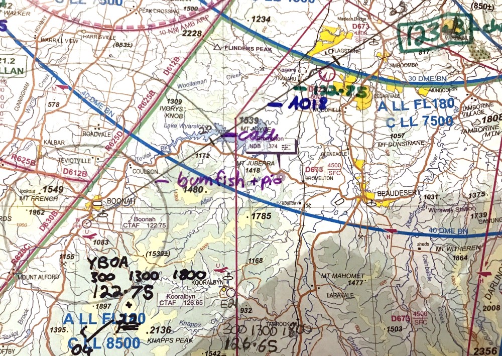
Navs and removable sticky tape.
in Student Pilot & Further Learning
Posted
That would stop them wearing out.